Category:Gowran
Jump to navigation
Jump to search
town in County Kilkenny, Ireland  | |||||
| Upload media | |||||
| Instance of | |||||
|---|---|---|---|---|---|
| Location | County Kilkenny, Leinster, Ireland | ||||
 | |||||
English: Gowran (Gabhrán in Irish) is a village and former town in County Kilkenny, Ireland. Gowran Park race course is located nearby. Gowran is located on the N9 national primary road where it is crossed by the R702 regional road.
Gaeilge: Sráidbhaile i g Contae Chill Chainnigh, Poblacht na hÉireann é Gabhrán (Béarla: Gowran). Tá sí suite ocht míle ó chathair Chill Chainnigh agus 80 míle ó mBaile Átha Cliath.
Italiano: Gowran (Gabhrán in irlandese) è un piccolo centro abitato dell'Irlanda, nella contea di Kilkenny, a 12 km da Kilkenny con una popolazione di circa 500 abitanti.
Subcategories
This category has the following 7 subcategories, out of 7 total.
B
- Bastionfort Well (4 F)
C
- Castle Ellis Bridge (4 F)
Media in category "Gowran"
The following 73 files are in this category, out of 73 total.
-
 Neale(1826) p3.250 - Gowran Castle, Kilkenny.jpg 1,840 × 1,276; 866 KB
-
 Abbey Ruin - geograph.org.uk - 6703868.jpg 800 × 600; 487 KB
-
 Barley Field - geograph.org.uk - 6517652.jpg 800 × 600; 996 KB
-
 Bridge and Lane - geograph.org.uk - 6517727.jpg 800 × 600; 1.05 MB
-
 Bridge and Sunset - geograph.org.uk - 5598444.jpg 640 × 480; 82 KB
-
 Bridge over the M9, Flagmount South - geograph.org.uk - 6082953.jpg 800 × 533; 436 KB
-

-

-
 Church and Graveyard - geograph.org.uk - 5695131.jpg 640 × 480; 81 KB
-
 Cottage Renovation - geograph.org.uk - 6517654.jpg 800 × 600; 856 KB
-
 Country Lane - geograph.org.uk - 6517637.jpg 800 × 600; 731 KB
-
 Country Laneway - geograph.org.uk - 6517699.jpg 800 × 600; 847 KB
-
 Country Laneway - geograph.org.uk - 6517709.jpg 800 × 600; 1.06 MB
-
 County Kilkenny - Market Cross, Gowran - 20230904142521.jpg 4,032 × 2,016; 3.68 MB
-
 Damaged Bridge - geograph.org.uk - 6518679.jpg 800 × 600; 1.11 MB
-
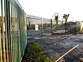
 Depot Entrance - geograph.org.uk - 5598359.jpg 640 × 480; 129 KB
-
 Drainage Culvert - geograph.org.uk - 6518673.jpg 800 × 600; 1.07 MB
-
 Drogheda Ironworks manhole cover.jpg 3,104 × 3,104; 4.91 MB
-
 Entrance and Drive - geograph.org.uk - 5598366.jpg 640 × 480; 140 KB
-
 Entrance Gate - geograph.org.uk - 6517644.jpg 800 × 600; 1.03 MB
-
 Entrance Gateway - geograph.org.uk - 6519280.jpg 800 × 600; 1.04 MB
-
 Farm Buildings - geograph.org.uk - 6703900.jpg 800 × 600; 761 KB
-
 Farm Entrance - geograph.org.uk - 6518671.jpg 800 × 600; 1.05 MB
-
 Farm Entrance - geograph.org.uk - 6519287.jpg 800 × 600; 882 KB
-
 Farm Operations - geograph.org.uk - 6517731.jpg 800 × 600; 709 KB
-
 Farm Track - geograph.org.uk - 6517631.jpg 800 × 600; 921 KB
-
 Feeding Trough - geograph.org.uk - 6517720.jpg 800 × 600; 1,016 KB
-
 Fence and Field - geograph.org.uk - 6519294.jpg 800 × 600; 924 KB
-
 Fields and Well - geograph.org.uk - 5598334.jpg 640 × 507; 185 KB
-
 Fountains, St. Mary's Church, Gowran - geograph.org.uk - 5221801.jpg 2,240 × 1,488; 1.56 MB
-
 Gated Area - geograph.org.uk - 6703895.jpg 800 × 600; 774 KB
-
 Gated Entrance - geograph.org.uk - 6703880.jpg 800 × 600; 874 KB
-
 Gowran Castle - geograph.org.uk - 475982.jpg 480 × 640; 39 KB
-
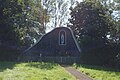
 Gowran Church - geograph.org.uk - 5598349.jpg 480 × 640; 101 KB
-
 Gowran Grotto (2).jpg 3,008 × 2,000; 6.33 MB
-
 Gowran Grotto 2.jpg 3,008 × 2,000; 2.97 MB
-
 Gowran National School - geograph.org.uk - 5598340.jpg 640 × 480; 79 KB
-
 Gowran Sewer vent coronet.jpg 1,839 × 1,209; 2.95 MB
-
 Gowran Sewer vent pedestal 01.jpg 2,000 × 3,008; 6.09 MB
-
 Grazing Sheep - geograph.org.uk - 6703903.jpg 800 × 600; 638 KB
-
 Grazing Sheep - geograph.org.uk - 6703905.jpg 800 × 600; 515 KB
-
 Hurling Ground - geograph.org.uk - 4991763.jpg 1,600 × 936; 263 KB
-
 Lane Junction - geograph.org.uk - 6517712.jpg 600 × 800; 977 KB
-
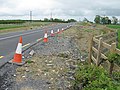
 M9 Northbound near Blanchfields Park - geograph.org.uk - 6082957.jpg 800 × 533; 541 KB
-
 M9 Northbound towards junction 7 - geograph.org.uk - 4795272.jpg 1,200 × 799; 285 KB
-
 M9 Northbound towards junction 7 - geograph.org.uk - 4795277.jpg 1,200 × 799; 337 KB
-
 M9 Northbound towards junction 7 - geograph.org.uk - 4795282.jpg 1,200 × 799; 264 KB
-
 M9 Northbound towards junction 7 - geograph.org.uk - 4795289.jpg 1,200 × 799; 253 KB
-
 Motorway Snow - geograph.org.uk - 5695117.jpg 640 × 480; 106 KB
-
 Motorway Snow - geograph.org.uk - 5695120.jpg 640 × 480; 92 KB
-
 Mud and Field - geograph.org.uk - 6703886.jpg 800 × 600; 656 KB
-
 Old Pump - geograph.org.uk - 6517666.jpg 800 × 600; 706 KB
-
 Packed Snow - geograph.org.uk - 5695124.jpg 640 × 451; 55 KB
-
 Rath Site - geograph.org.uk - 5598378.jpg 640 × 425; 106 KB
-
 Road and Bridge - geograph.org.uk - 6518686.jpg 800 × 600; 1.04 MB
-
 Road Bridge - geograph.org.uk - 6517677.jpg 800 × 600; 902 KB
-
 Road Construction - geograph.org.uk - 1320952.jpg 640 × 480; 72 KB
-
 Road Construction - geograph.org.uk - 1320963.jpg 640 × 480; 105 KB
-
 Road Junction - geograph.org.uk - 5598353.jpg 640 × 480; 109 KB
-
 Road Junction - geograph.org.uk - 6519274.jpg 800 × 600; 917 KB
-
 Road Junction - geograph.org.uk - 6519301.jpg 800 × 600; 794 KB
-
 Road Junction - geograph.org.uk - 6620473.jpg 800 × 600; 873 KB
-
 Road Junction - geograph.org.uk - 6703871.jpg 800 × 600; 781 KB
-
 Road Junction - geograph.org.uk - 6703873.jpg 800 × 600; 865 KB
-
 Roadside Fence - geograph.org.uk - 5598364.jpg 640 × 480; 126 KB
-
 Row Housing - geograph.org.uk - 6519305.jpg 800 × 600; 742 KB
-
 School Plaque - geograph.org.uk - 5598347.jpg 640 × 425; 98 KB
-
 Snow in Gowran - geograph.org.uk - 5695128.jpg 640 × 480; 111 KB
-
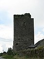
 Tower House - geograph.org.uk - 5883008.jpg 600 × 800; 243 KB
-
 Tree Lined Avenue - geograph.org.uk - 6519282.jpg 800 × 600; 723 KB
-
 Village Boundary - geograph.org.uk - 6519298.jpg 800 × 600; 886 KB
-
 Yellow Field - geograph.org.uk - 6806873.jpg 800 × 600; 237 KB
-
 Bridge at Brickana - geograph.org.uk - 523557.jpg 640 × 480; 90 KB
_p3.250_-_Gowran_Castle,_Kilkenny.jpg)


.jpg)


