Category:Gotische Huis, Goes
Jump to navigation
Jump to search
| Object location | | View all coordinates using: OpenStreetMap |
|---|
 | |||||
| Upload media | |||||
| Instance of | |||||
|---|---|---|---|---|---|
| Location | Goes, Zeeland, Netherlands | ||||
| Street address |
| ||||
| Located on street | |||||
| Owned by |
| ||||
| Heritage designation |
| ||||
| Inception |
| ||||
 | |||||
|
This is a category about rijksmonument number 16383
|
| Address |
|
Media in category "Gotische Huis, Goes"
The following 44 files are in this category, out of 44 total.
-
 Exterieur OVERZICHT - Goes - 20261918 - RCE.jpg 2,385 × 1,906; 979 KB
-
 Exterieur OVERZICHT - Goes - 20261919 - RCE.jpg 1,200 × 878; 115 KB
-
 Exterieur OVERZICHT - Goes - 20261923 - RCE.jpg 1,200 × 938; 160 KB
-
 Exterieur OVERZICHT - Goes - 20261924 - RCE.jpg 2,406 × 1,878; 1.01 MB
-
 Exterieur OVERZICHT VOORGEVELS - Goes - 20299033 - RCE.jpg 3,042 × 3,077; 3.5 MB
-
 Exterieur OVERZICHT VOORGEVELS - Goes - 20299035 - RCE.jpg 3,042 × 3,079; 3.21 MB
-
 Gevel - Goes - 20079886 - RCE.jpg 2,451 × 3,100; 3.02 MB
-
 Gevel - Goes - 20079887 - RCE.jpg 2,434 × 3,060; 2.76 MB
-
 Gevelwand - Goes - 20335883 - RCE.jpg 3,014 × 2,991; 4.52 MB
-
 Gevelwand - Goes - 20335884 - RCE.jpg 3,060 × 2,440; 3.42 MB
-
 Goes Turfkade 11.jpg 1,712 × 2,288; 760 KB
-
 Goes Turfkade 13.jpg 1,712 × 2,288; 811 KB
-
 Gotische Huis, Goes.jpg 1,772 × 1,495; 687 KB
-
 Gotische Huis, Goes2.jpg 790 × 1,427; 427 KB
-
 Hoek Turfkade - Goes - 20079651 - RCE.jpg 3,256 × 2,212; 2.63 MB
-
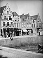 Huizen aan de, Huis aan de, lichtdruk J.J.v.Ysendyck, pl.260 - Goes - 20079873 - RCE.jpg 2,279 × 3,118; 2.88 MB
-
 Interieur, begane grond, balklaag - Goes - 20335892 - RCE.jpg 3,014 × 2,996; 1.91 MB
-
 Interieur, begane grond, balklaag sleutelstuk (1555) - Goes - 20335894 - RCE.jpg 3,014 × 2,990; 2.45 MB
-
 Interieur, begane grond, balklaag sleutelstuk - Goes - 20335893 - RCE.jpg 2,984 × 2,996; 2.14 MB
-
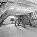 Interieur, kap met hijswiel - Goes - 20335896 - RCE.jpg 3,014 × 3,014; 2.54 MB
-
 Interieur, kapspanten - Goes - 20335897 - RCE.jpg 3,020 × 3,044; 2.51 MB
-
 Interieur, keldergewelf onder binnenkamer - Goes - 20335890 - RCE.jpg 3,014 × 3,020; 2.36 MB
-
 Interieur, keuken in achterhuis - Goes - 20335889 - RCE.jpg 3,014 × 3,014; 2 MB
-
 Interieur, overzicht kap - Goes - 20335895 - RCE.jpg 3,014 × 3,026; 3.87 MB
-
 Interieur, voorkamer eerste verdieping - Goes - 20335887 - RCE.jpg 3,014 × 3,038; 3.83 MB
-
 Interieur, voorkamer eerste verdieping - Goes - 20335888 - RCE.jpg 3,020 × 3,002; 3.75 MB
-

-
 Overzicht - Goes - 20079538 - RCE.jpg 2,088 × 2,086; 1.03 MB
-
 Overzicht - Goes - 20079868 - RCE.jpg 2,045 × 2,550; 1.46 MB
-
 Overzicht - Goes - 20079869 - RCE.jpg 3,060 × 2,455; 1.79 MB
-
 Overzicht - Goes - 20079870 - RCE.jpg 3,308 × 2,228; 1.62 MB
-
 Overzicht - Goes - 20079872 - RCE.jpg 3,296 × 2,224; 1.69 MB
-
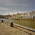
 Overzicht met de Haven op de voorgrond - Goes - 20379824 - RCE.jpg 3,090 × 3,090; 1.81 MB
-
 Overzicht Turfkade - Goes - 20079874 - RCE.jpg 3,824 × 2,849; 1.86 MB
-
 Overzicht van de Kleine Kade, gezien vanaf de Grote Kade - Goes - 20420415 - RCE.jpg 3,836 × 2,536; 1.87 MB
-
 Overzicht van de voorgevels met de Haven op de voorgrond - Goes - 20379825 - RCE.jpg 3,090 × 3,090; 1.84 MB
-
 Overzicht voorgevels - Goes - 20079875 - RCE.jpg 2,849 × 3,824; 1.92 MB
-
 Turfkade (Goes).jpg 1,842 × 1,113; 510 KB
-
 Turfkade, overzicht - Goes - 20079882 - RCE.jpg 3,100 × 2,480; 1.81 MB
-
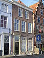
 Voorgevel - Goes - 20079885 - RCE.jpg 2,416 × 3,100; 1.76 MB
-
 Voorgevel - Goes - 20335885 - RCE.jpg 2,406 × 3,055; 2.02 MB
-
 Voorgevel, begane grond, geprofileerde nis met gelobde boog - Goes - 20335886 - RCE.jpg 2,412 × 3,049; 2.05 MB
-
 Voorgevels - Goes - 20079883 - RCE.jpg 2,200 × 3,273; 1.59 MB
-
 Voorgevels naar IJsendijcke - Goes - 20079884 - RCE.jpg 2,026 × 2,688; 1.25 MB


_-_Goes_-_20335894_-_RCE.jpg)


.jpg)


