Category:Godley, Greater Manchester
Jump to navigation
Jump to search
English: Godley is a suburb of Hyde, in the unparished area of Hyde, in the Tameside district, in the county of Greater Manchester, England.
suburb in Hyde, Greater Manchester | |||||
| Upload media | |||||
| Instance of | |||||
|---|---|---|---|---|---|
| Location | Tameside, Greater Manchester, North West England, England | ||||
 | |||||
Subcategories
This category has the following 4 subcategories, out of 4 total.
G
- Godley East railway station (3 F)
- Godley Hill (46 F)
- Godley railway station (22 F)
Media in category "Godley, Greater Manchester"
The following 146 files are in this category, out of 146 total.
-
 A remnant of the railway - geograph.org.uk - 3570660.jpg 640 × 579; 269 KB
-
 A Tight Squeeze - geograph.org.uk - 1011234.jpg 640 × 481; 153 KB
-
 Access to Godley Reservoir - geograph.org.uk - 3897657.jpg 1,000 × 1,000; 422 KB
-
 Almond Way - geograph.org.uk - 3570705.jpg 640 × 413; 119 KB
-
 Almond Way, Godley - geograph.org.uk - 3748607.jpg 640 × 480; 78 KB
-
 Approaching the Godley Turntable - geograph.org.uk - 4425551.jpg 1,000 × 750; 1,016 KB
-
 Approaching the Godley Turntable - geograph.org.uk - 4919927.jpg 1,000 × 750; 1.02 MB
-
 Approaching the Godley Turntable - geograph.org.uk - 6250621.jpg 1,280 × 1,004; 1.2 MB
-
 Approaching the Railway Bridge - Mottram Road - geograph.org.uk - 2003368.jpg 4,224 × 3,168; 5.93 MB
-
 Barmhouse (Waterworks Lane) - geograph.org.uk - 2702254.jpg 1,280 × 960; 1.05 MB
-
 Barmhouse Lane - geograph.org.uk - 1036474.jpg 640 × 503; 138 KB
-
 Behind the Godley Turntable - geograph.org.uk - 4425566.jpg 1,000 × 750; 1,012 KB
-
 Bridge HAJ-43 - geograph.org.uk - 4180452.jpg 1,000 × 687; 601 KB
-
 Bridge HAJ-43 Sign - geograph.org.uk - 4180562.jpg 1,000 × 882; 772 KB
-
 Brookbank Folly Castle (geograph 7291391).jpg 1,920 × 1,919; 3.42 MB
-
 Brookbank Folly Castle - geograph.org.uk - 2870803.jpg 640 × 501; 287 KB
-
 Brookbank Folly Castle - geograph.org.uk - 2870806.jpg 640 × 853; 305 KB
-
 Brookbank Folly Castle - geograph.org.uk - 2870808.jpg 622 × 640; 229 KB
-
 Brookbank Folly Castle - geograph.org.uk - 4608736.jpg 1,000 × 750; 882 KB
-
 Brookbank Folly Castle - geograph.org.uk - 4608741.jpg 1,000 × 750; 949 KB
-
 Brookfold Bridge - geograph.org.uk - 4429039.jpg 1,000 × 750; 829 KB
-
 Brookfold Farm - geograph.org.uk - 3569929.jpg 640 × 480; 225 KB
-
 Brookfold Farm - geograph.org.uk - 4180363.jpg 1,000 × 750; 621 KB
-
 Brookfold Farm - geograph.org.uk - 4427718.jpg 1,000 × 750; 682 KB
-
 Brookfold Farm - geograph.org.uk - 4919931.jpg 1,000 × 750; 728 KB
-
 Brookfold Lane - geograph.org.uk - 3570710.jpg 640 × 480; 232 KB
-
 Brookfold Lane from Brookfold Bridge - geograph.org.uk - 4428810.jpg 1,000 × 750; 879 KB
-
 Brookfold Lane, Godley - geograph.org.uk - 3748611.jpg 640 × 480; 118 KB
-
 End of Oaklands Road, Godley - geograph.org.uk - 3748415.jpg 640 × 480; 68 KB
-

-
 Firethorn Drive - geograph.org.uk - 1800836.jpg 640 × 468; 111 KB
-
 Firethorn Drive, Godley - geograph.org.uk - 3748457.jpg 640 × 480; 68 KB
-
 Footpath from Godley - geograph.org.uk - 1052390.jpg 640 × 480; 198 KB
-
 Footpath to Brookfold Lane - geograph.org.uk - 4429105.jpg 1,000 × 594; 364 KB
-
 Footpath to Godley - geograph.org.uk - 1052393.jpg 640 × 480; 185 KB
-
 Footpath to Station Road - geograph.org.uk - 4429087.jpg 1,000 × 750; 661 KB
-
 Footpath up to Godley - geograph.org.uk - 2444695.jpg 1,024 × 768; 282 KB
-
 Former Railway Turntable - geograph.org.uk - 1800551.jpg 640 × 480; 190 KB
-
 Godley and Hyde Boundary - geograph.org.uk - 4541566.jpg 1,000 × 636; 475 KB
-
 Godley Arches - geograph.org.uk - 2702216.jpg 1,280 × 960; 932 KB
-
 Godley Arches - geograph.org.uk - 3897656.jpg 1,000 × 1,000; 347 KB
-
 Godley Arches - geograph.org.uk - 5045804.jpg 1,000 × 691; 666 KB
-

-
 Godley Footpath - geograph.org.uk - 2870811.jpg 640 × 480; 288 KB
-
 Godley Footpath - geograph.org.uk - 2870821.jpg 640 × 500; 286 KB
-
 Godley Green - geograph.org.uk - 1800507.jpg 640 × 419; 97 KB
-
 Godley Green - geograph.org.uk - 2444143.jpg 640 × 513; 126 KB
-
 Godley Green - geograph.org.uk - 3569941.jpg 640 × 581; 184 KB
-
 Godley Green - geograph.org.uk - 4314662.jpg 1,000 × 751; 493 KB
-
 Godley Green - geograph.org.uk - 4605918.jpg 1,000 × 750; 613 KB
-
 Godley Green - geograph.org.uk - 5392793.jpg 1,024 × 768; 609 KB
-
 Godley Hall Inn - geograph.org.uk - 2403029.jpg 640 × 555; 163 KB
-
 Godley Hall Inn - geograph.org.uk - 2403036.jpg 640 × 403; 123 KB
-
 Godley Hall Inn - geograph.org.uk - 2702127.jpg 1,280 × 960; 796 KB
-
 Godley Junction - geograph.org.uk - 3570041.jpg 639 × 640; 153 KB
-
 Godley Junction - geograph.org.uk - 4427817.jpg 1,000 × 750; 948 KB
-
 Godley Junction marshalling yard - geograph.org.uk - 828018.jpg 640 × 464; 92 KB
-
 Godley Junction Station Yard - geograph.org.uk - 3570082.jpg 640 × 480; 185 KB
-
 Godley Junction to Apethorn Railway - geograph.org.uk - 3570639.jpg 640 × 480; 259 KB
-
 Godley Off Licence ^ Convenience Store - geograph.org.uk - 2444512.jpg 640 × 480; 206 KB
-
 Godley St John's - geograph.org.uk - 1052411.jpg 640 × 521; 180 KB
-
 Godley St John's - geograph.org.uk - 1052418.jpg 640 × 480; 148 KB
-
 Godley Turntable - geograph.org.uk - 3569644.jpg 640 × 480; 239 KB
-
 Godley turntable - geograph.org.uk - 3569649.jpg 640 × 480; 240 KB
-
 Godley Turntable - geograph.org.uk - 3569652.jpg 640 × 480; 265 KB
-
 Godley Turntable - geograph.org.uk - 4425585.jpg 1,000 × 750; 901 KB
-
 Godley Turntable - geograph.org.uk - 4425613.jpg 1,000 × 750; 845 KB
-
 Godley Turntable - geograph.org.uk - 4426018.jpg 1,000 × 750; 943 KB
-
 Godley Turntable - geograph.org.uk - 4919928.jpg 1,000 × 750; 878 KB
-
 Godley Turntable - geograph.org.uk - 4919971.jpg 1,000 × 750; 913 KB
-
 Godley Turntable - geograph.org.uk - 6250801.jpg 1,280 × 960; 1.12 MB
-
 Godley Turntable - geograph.org.uk - 6250846.jpg 1,280 × 960; 1,024 KB
-
 Godley Vale - geograph.org.uk - 1036577.jpg 636 × 640; 176 KB
-
 Godley Viaduct - geograph.org.uk - 2702125.jpg 1,280 × 960; 1.01 MB
-
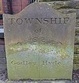
 Godley-Hyde Township boundary stone - geograph.org.uk - 4541561.jpg 1,000 × 1,000; 843 KB
-
 Graffiti at Godley Junction - geograph.org.uk - 3570691.jpg 640 × 480; 265 KB
-
 Grazing land off Station Road, Godley - geograph.org.uk - 4429097.jpg 1,000 × 670; 465 KB
-
 Green Field, Godley - geograph.org.uk - 2702205.jpg 1,280 × 960; 1.13 MB
-
 Green Lane - geograph.org.uk - 4606121.jpg 1,000 × 788; 662 KB
-
 Green Lane Bridge - geograph.org.uk - 4606103.jpg 1,000 × 750; 611 KB
-
 Hidden access - geograph.org.uk - 5045800.jpg 1,000 × 1,000; 1.09 MB
-
 High Street Godley - geograph.org.uk - 1052408.jpg 640 × 464; 110 KB
-
 Inspection pit at Godley turntable - geograph.org.uk - 4919975.jpg 1,000 × 750; 1.12 MB
-
 Kerry Foods, Godley, Hyde - geograph.org.uk - 1864982.jpg 3,723 × 2,489; 4.24 MB
-
 Kerry Way - geograph.org.uk - 4180769.jpg 1,000 × 750; 592 KB
-
 Kerry Way - geograph.org.uk - 4180780.jpg 1,000 × 750; 584 KB
-
 Kerry Way - geograph.org.uk - 4429145.jpg 1,000 × 838; 662 KB
-
 Longlands Wood - geograph.org.uk - 1858520.jpg 640 × 497; 132 KB
-
 Looking across the Godley Turntable - geograph.org.uk - 6250806.jpg 1,280 × 960; 1.14 MB
-
 Looking across the Godley Turntable - geograph.org.uk - 6250939.jpg 1,280 × 960; 1.34 MB
-
 Looking under Godley Arches - geograph.org.uk - 5045788.jpg 1,000 × 862; 866 KB
-
 Magpie on Green Lane Bridge - geograph.org.uk - 3569621.jpg 1,646 × 1,646; 1.13 MB
-
 New houses on Pudding Lane - geograph.org.uk - 3828205.jpg 1,000 × 750; 265 KB
-
 New Road at Godley - geograph.org.uk - 3367143.jpg 640 × 463; 129 KB
-
 Newton Cricket Club - geograph.org.uk - 5753820.jpg 1,024 × 577; 94 KB
-
 No access to Station Road - geograph.org.uk - 4180459.jpg 1,000 × 793; 761 KB
-
 Nodding donkey^ - geograph.org.uk - 4432935.jpg 1,000 × 1,000; 1.02 MB
-
 Oak Tree Close - geograph.org.uk - 4433196.jpg 1,000 × 750; 819 KB
-
 Oaklands Hall - geograph.org.uk - 3171518.jpg 640 × 570; 220 KB
-
 Oaklands Hall - geograph.org.uk - 3962966.jpg 1,000 × 710; 273 KB
-
 Oaklands Road - geograph.org.uk - 3171465.jpg 640 × 480; 215 KB
-
 Oaklands Road, Godley - geograph.org.uk - 3748398.jpg 640 × 480; 128 KB
-
 Oaklands Wood - geograph.org.uk - 3171476.jpg 640 × 503; 221 KB
-
 Oaklands Wood - geograph.org.uk - 3171486.jpg 640 × 535; 213 KB
-
-
 Old platform at Godley Junction - geograph.org.uk - 4428710.jpg 1,000 × 750; 1,008 KB
-
 Old railway paraphernalia - geograph.org.uk - 1800796.jpg 640 × 480; 219 KB
-
 Overgrown footpath - geograph.org.uk - 4608810.jpg 1,000 × 750; 931 KB
-
 Overgrown valley - geograph.org.uk - 4605395.jpg 1,000 × 750; 1.05 MB
-
 Path to Godley - geograph.org.uk - 2444804.jpg 640 × 480; 227 KB
-

-
 Pond at Godley East - geograph.org.uk - 4428784.jpg 1,000 × 750; 1.03 MB
-
 Pudding Fold - geograph.org.uk - 3828186.jpg 1,000 × 750; 260 KB
-
 Shadows across the turntable pit - geograph.org.uk - 4919929.jpg 1,000 × 750; 895 KB
-
 Sheffield Road, Godley - geograph.org.uk - 2702229.jpg 1,280 × 960; 1.08 MB
-
 Sign of Godley Hall Inn - geograph.org.uk - 2403049.jpg 532 × 640; 175 KB
-
 Site of Godley Turntable - geograph.org.uk - 4180332.jpg 3,264 × 2,448; 6.48 MB
-
 Site of Godley Turntable - geograph.org.uk - 4180336.jpg 1,000 × 750; 1.07 MB
-
 St Michael's Road - geograph.org.uk - 4607682.jpg 1,000 × 797; 527 KB
-
 Station Road - geograph.org.uk - 1732663.jpg 640 × 471; 142 KB
-
 Station Road, Godley - geograph.org.uk - 3748618.jpg 640 × 480; 102 KB
-
 Steep path by Godley Wood - geograph.org.uk - 2444790.jpg 640 × 480; 240 KB
-
 Steps on a footpath - geograph.org.uk - 4609102.jpg 1,000 × 1,000; 1.05 MB
-
 Sustrans Milepost at Godley - geograph.org.uk - 6250902.jpg 1,280 × 960; 1.37 MB
-
 Swindell's Fold, Godley - geograph.org.uk - 1801067.jpg 640 × 480; 134 KB
-
 The bottom of Green Lane - geograph.org.uk - 4607815.jpg 1,000 × 750; 679 KB
-
 The bottom of Green Lane - geograph.org.uk - 4607826.jpg 1,000 × 750; 748 KB
-
 The top of St Paul's Hill Road - geograph.org.uk - 4606155.jpg 1,000 × 750; 531 KB
-
 The valley of the Werneth Brook - geograph.org.uk - 4605386.jpg 1,000 × 750; 1.01 MB
-
 The view from Brookfold Bridge - geograph.org.uk - 4919941.jpg 1,000 × 750; 857 KB
-
 Track off Halton Street - geograph.org.uk - 3015466.jpg 640 × 480; 226 KB
-
 Track to Brookfold - geograph.org.uk - 1007677.jpg 640 × 480; 161 KB
-
 Track towards Godley Reservoir - geograph.org.uk - 1007684.jpg 640 × 480; 153 KB
-
 Track Towards Woodside - geograph.org.uk - 2702364.jpg 1,280 × 960; 1.1 MB
-
 Trans-Pennine Trail - geograph.org.uk - 798164.jpg 640 × 480; 200 KB
-
 Turntable revealed - geograph.org.uk - 4919967.jpg 1,000 × 750; 1,014 KB
-
 Under Godley Arches - geograph.org.uk - 2015332.jpg 640 × 576; 194 KB
-
 United Utilities Water Treatment Works, Godley - geograph.org.uk - 2702304.jpg 1,280 × 960; 800 KB
-
 View along the old track - geograph.org.uk - 4427689.jpg 1,000 × 750; 929 KB
-
 View from Brookfold Lane Bridge - geograph.org.uk - 3569920.jpg 640 × 521; 196 KB
-
 Vincent Park - geograph.org.uk - 2557648.jpg 640 × 480; 219 KB
-
 Vincent Park - geograph.org.uk - 2557666.jpg 640 × 608; 182 KB
-
 Vincent Park - geograph.org.uk - 2702221.jpg 960 × 1,280; 1.17 MB
-
 Vincent Park, Godley - geograph.org.uk - 2702223.jpg 1,280 × 960; 1.25 MB
-
 Where have the trains gone^ - geograph.org.uk - 2401712.jpg 640 × 480; 257 KB
-
 Where have the trains gone^ - geograph.org.uk - 2401724.jpg 640 × 480; 259 KB


_-_geograph.org.uk_-_2702254.jpg)


.jpg)


