Category:Gobion Fawr
Jump to navigation
Jump to search
English: Gobion Fawr is a community in the principal area of Monmouthshire, Wales.
community in Monmouthshire, Wales, UK  | |||||
| Upload media | |||||
| Instance of | |||||
|---|---|---|---|---|---|
| Location | Monmouthshire, Wales | ||||
| Population |
| ||||
| official website | |||||
| |||||
Subcategories
This category has the following 3 subcategories, out of 3 total.
C
- Court Farmhouse, Gobion Fawr (1 F)
L
Media in category "Gobion Fawr"
The following 72 files are in this category, out of 72 total.
-
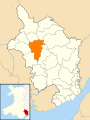 2024 Wales Monmouthshire Community Gobion Fawr map.svg 512 × 682; 603 KB
-

-
 A4042 at Lianover village boundary - geograph.org.uk - 5064072.jpg 640 × 480; 59 KB
-
 A4042 southbound - geograph.org.uk - 5064063.jpg 640 × 481; 50 KB
-
 B4598 by Laurel Cottage - geograph.org.uk - 3620910.jpg 640 × 427; 66 KB
-

-

-
 Chain Bridge and Chain Bridge Inn - geograph.org.uk - 6328639.jpg 4,673 × 3,115; 2.18 MB
-
 Cherry Tree Cottages, Llanfair Kilgeddin - geograph.org.uk - 5394656.jpg 800 × 628; 124 KB
-
 Croes Llanvair from the west - geograph.org.uk - 3659635.jpg 1,024 × 768; 156 KB
-
 Crossroads on the way to Llanover - geograph.org.uk - 3659661.jpg 1,024 × 768; 177 KB
-

-

-

-
 Farm Track near White Horse Farm - geograph.org.uk - 5208847.jpg 4,000 × 3,000; 5.13 MB
-

-

-

-

-

-

-

-
 Gobion Telephone Exchange - geograph.org.uk - 6520675.jpg 2,592 × 1,944; 1.35 MB
-

-
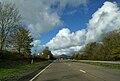
 Heading west on the A40 - geograph.org.uk - 5606409.jpg 640 × 428; 65 KB
-

-

-
 Large stone barn, Pistyll Farm - geograph.org.uk - 3658442.jpg 1,024 × 768; 182 KB
-
 Llanfair Kilgeddin Village Hall - geograph.org.uk - 5390425.jpg 800 × 670; 140 KB
-
 Llanfair Kilgeddin Village Hall - geograph.org.uk - 5390430.jpg 800 × 695; 149 KB
-

-
 Llanvapley Sports Pavilion - geograph.org.uk - 5537501.jpg 2,592 × 1,456; 911 KB
-

-

-
 No Road Markings - geograph.org.uk - 6392940.jpg 3,264 × 4,896; 2.54 MB
-

-
 Oak tree alongside the track to Waun Ruffyn - geograph.org.uk - 3659652.jpg 1,024 × 768; 142 KB
-
 On the A40 heading for Abergavenny - geograph.org.uk - 5606430.jpg 640 × 433; 65 KB
-

-
 On the A40, heading for Abergavenny - geograph.org.uk - 5606436.jpg 640 × 382; 63 KB
-

-

-

-
 Postbox at Llanvair - geograph.org.uk - 3659642.jpg 1,024 × 768; 155 KB
-
 Postbox near Great Hardwick - geograph.org.uk - 5544060.jpg 640 × 447; 68 KB
-
 Preparing to move the sheep, Pistyll Farm - geograph.org.uk - 3658462.jpg 1,024 × 615; 108 KB
-

-
 Railway bridge at The Bryn - geograph.org.uk - 6392933.jpg 4,633 × 3,089; 2.6 MB
-
 River Usk - geograph.org.uk - 6393723.jpg 4,896 × 3,264; 4.76 MB
-
 Sheep at Pistyll Farm - geograph.org.uk - 3658436.jpg 1,024 × 768; 115 KB
-

-
 St Mary's, Llanfair Kilgeddin - geograph.org.uk - 5546502.jpg 1,600 × 1,200; 403 KB
-
 St Michael's church, Llanvihangel Gobion - geograph.org.uk - 5676753.jpg 1,600 × 1,200; 645 KB
-
 Straight on for Usk - Brynbuga - geograph.org.uk - 3659671.jpg 1,024 × 768; 182 KB
-
 Stubble field south of Fro-fawr Farm - geograph.org.uk - 3659677.jpg 1,024 × 768; 154 KB
-

-
 The narrow lane to Pistyll - geograph.org.uk - 3658473.jpg 1,024 × 768; 153 KB
-
 The River Usk near The Bryn - geograph.org.uk - 6451854.jpg 1,799 × 1,199; 500 KB
-
 The road to Croes Llanvair - geograph.org.uk - 3658486.jpg 1,024 × 768; 140 KB
-
 The road to Croes Llanvair - geograph.org.uk - 3659657.jpg 1,024 × 768; 169 KB
-
 The road to Llanfair Kilgeddin - geograph.org.uk - 3658478.jpg 1,024 × 768; 165 KB
-
 The road to Llanfair Kilgeddin - geograph.org.uk - 3659640.jpg 1,023 × 768; 183 KB
-
 The road to Llanover - geograph.org.uk - 3659645.jpg 1,024 × 768; 152 KB
-
 The road to the A4042 - geograph.org.uk - 3659667.jpg 1,024 × 768; 196 KB
-
 The Usk Valley - geograph.org.uk - 5544067.jpg 640 × 480; 63 KB
-
 Tredilion Farm - geograph.org.uk - 5871504.jpg 640 × 449; 69 KB
-
 Trees along the road to Llanover - geograph.org.uk - 3659648.jpg 1,024 × 768; 125 KB
-

-

-
 Ty-capel Farm - geograph.org.uk - 5871506.jpg 640 × 421; 62 KB
-
 View to Garn Clochdy - geograph.org.uk - 3620908.jpg 640 × 427; 80 KB
-


