Category:Gmina Office in Sobótka
Jump to navigation
Jump to search
| Object location | | View all coordinates using: OpenStreetMap |
|---|
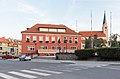
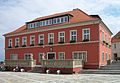
seat of local government in Sobótka, Lower Silesian Voivodeship, Poland  | |||||
| Upload media | |||||
| Instance of | |||||
|---|---|---|---|---|---|
| Location | Sobótka, Lower Silesian Voivodeship, Poland | ||||
| Street address |
| ||||
| Heritage designation |
| ||||
 | |||||
Media in category "Gmina Office in Sobótka"
The following 7 files are in this category, out of 7 total.
-
 2016 Urząd Miasta i Gminy w Sobótce 1.jpg 3,852 × 2,594; 6.18 MB
-
 2016 Urząd Miasta i Gminy w Sobótce 2.jpg 2,879 × 1,964; 3.03 MB
-
 2016 Urząd Miasta i Gminy w Sobótce 3.jpg 3,345 × 2,208; 4.07 MB
-
 2016 Urząd Miasta i Gminy w Sobótce 4.jpg 3,630 × 2,538; 4.62 MB
-
 2016 Urząd Miasta i Gminy w Sobótce 5.jpg 3,139 × 2,205; 4.13 MB
-
 Rathausvonzobten.JPG 2,835 × 1,969; 2.67 MB
-
 Sobótka, ratusz 02.jpg 4,199 × 2,801; 1.87 MB


