Category:Gloslunde Kirke
Jump to navigation
Jump to search
| Object location | | View all coordinates using: OpenStreetMap |
|---|
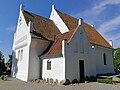
church building in Lolland Municipality, Denmark  | |||||
| Upload media | |||||
| Instance of | |||||
|---|---|---|---|---|---|
| Location | Gloslunde, Lolland Municipality, Region Zealand, Denmark | ||||
| Street address |
| ||||
| Diocese | |||||
| Religion or worldview | |||||
 | |||||
Media in category "Gloslunde Kirke"
The following 6 files are in this category, out of 6 total.
-
 06-04-02-k3 Gloslunde (Lolland).JPG 750 × 485; 230 KB
-
 06-04-02-k5 Gloslunde (Lolland).JPG 750 × 564; 360 KB
-
 06-04-02-k6 Gloslunde (Lolland).JPG 750 × 547; 243 KB
-
 Gloslunde kirke 01.jpg 3,869 × 2,903; 1.75 MB
-
 Gloslunde Kirke 01.jpg 3,000 × 1,987; 2.76 MB
-
 Gloslunde kirke, Lolland 01.jpg 3,879 × 2,909; 2.78 MB
.JPG)
.JPG)
.JPG)

