Category:Glen Quoich, Highland
Jump to navigation
Jump to search

Media in category "Glen Quoich, Highland"
The following 49 files are in this category, out of 49 total.
-
 Am Bàthaich - geograph.org.uk - 1721217.jpg 640 × 359; 18 KB
-
 Am Bàthaich - geograph.org.uk - 1721333.jpg 480 × 640; 39 KB
-
 Birches, Glen Quoich - geograph.org.uk - 1721385.jpg 640 × 359; 86 KB
-
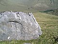
 Boulder in Upper Glen Quoich - geograph.org.uk - 1576757.jpg 640 × 480; 87 KB
-
-
 Confluence, River Quoich - geograph.org.uk - 187570.jpg 640 × 480; 303 KB
-
 Easter Glen Quoich - geograph.org.uk - 1721340.jpg 640 × 359; 40 KB
-
 Easter Glen Quoich - geograph.org.uk - 939399.jpg 640 × 480; 80 KB
-
 Glen Quioch from Druim Seileach - geograph.org.uk - 98323.jpg 480 × 640; 86 KB
-
 Glen Quoich - geograph.org.uk - 1721345.jpg 640 × 359; 44 KB
-
 Glen Quoich - geograph.org.uk - 1732438.jpg 640 × 359; 76 KB
-
 Glen Quoich - geograph.org.uk - 1732452.jpg 640 × 359; 62 KB
-
 Glen Quoich Bridge - geograph.org.uk - 1720221.jpg 640 × 359; 105 KB
-
 Loch Loyne - geograph.org.uk - 1103843.jpg 640 × 359; 58 KB
-
 Looking down on Alltbeithe - geograph.org.uk - 983313.jpg 640 × 480; 127 KB
-

-
 Meall Blair - geograph.org.uk - 1157173.jpg 640 × 480; 64 KB
-
 Quoich confluence - geograph.org.uk - 1721142.jpg 640 × 359; 79 KB
-
 River Quoich - geograph.org.uk - 1721442.jpg 640 × 359; 73 KB
-
 River Quoich - geograph.org.uk - 1721448.jpg 640 × 359; 76 KB
-
 Road from Alltbeithe - geograph.org.uk - 1731458.jpg 640 × 359; 74 KB
-
 Road to Alltbeithe - geograph.org.uk - 1721126.jpg 640 × 359; 63 KB
-
 Ruin at Glacachuilinn - geograph.org.uk - 1144015.jpg 640 × 483; 186 KB
-
 Ruin at Glacachuilinn - geograph.org.uk - 1144019.jpg 640 × 484; 155 KB
-
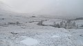
 Snow shower, Glen Quoich - geograph.org.uk - 1721353.jpg 640 × 359; 35 KB
-
 Solitary tree - geograph.org.uk - 1322428.jpg 640 × 480; 90 KB
-

-
 Summit cairn Spidean Mialach - geograph.org.uk - 98278.jpg 640 × 480; 82 KB
-
 Track in Glen Quoich - geograph.org.uk - 1143613.jpg 640 × 542; 140 KB
-
 Track in Glen Quoich - geograph.org.uk - 1143627.jpg 640 × 507; 179 KB
-
 Tree and track, Loch Quoich - geograph.org.uk - 187564.jpg 640 × 465; 258 KB
-
 Tree trunks in peat bog - geograph.org.uk - 1576801.jpg 480 × 640; 131 KB
-
 Tree-filled gully - geograph.org.uk - 1143970.jpg 640 × 552; 181 KB
-
 Wester Glen Quoich Burn - geograph.org.uk - 1576797.jpg 640 × 480; 75 KB
-
 Above Glen Quioch - geograph.org.uk - 310336.jpg 640 × 480; 74 KB
-
 Alltbeithe - geograph.org.uk - 1424647.jpg 640 × 480; 62 KB
-

-
 Bealach Coire Sgoireadail - geograph.org.uk - 654500.jpg 640 × 480; 84 KB
-
 Bealach Coire Sgoireadail - geograph.org.uk - 654657.jpg 640 × 480; 110 KB
-
 Bealach Dhuibh Leac - geograph.org.uk - 28625.jpg 640 × 425; 60 KB
-
 Bridge, River Quoich - geograph.org.uk - 187567.jpg 640 × 480; 292 KB
-
 Crossing of paths - geograph.org.uk - 484616.jpg 800 × 600; 695 KB
-
 Glen Quoich - geograph.org.uk - 554899.jpg 640 × 480; 44 KB
-
 Glen Quoich bridge - geograph.org.uk - 554903.jpg 640 × 480; 80 KB
-

-
 Loch Quoich - geograph.org.uk - 554896.jpg 640 × 480; 51 KB
-

-
 Sgurr an Lochain - geograph.org.uk - 654651.jpg 640 × 480; 45 KB
-
 The Kinloch Hourn road - geograph.org.uk - 554905.jpg 640 × 480; 63 KB


