Category:Glöstorpskyrkan
Jump to navigation
Jump to search
| Object location | | View all coordinates using: OpenStreetMap |
|---|
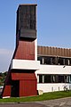
Svenska: Glöstorpskyrkan tillhör Tuve-Säve församling, Backa pastorat, Göteborgs norra kontrakt, Göteborgs stift / Diocese of Gothenburg.
church building in Gothenburg Municipality, Gothenburg and Bohus County, Sweden  | |||||
| Upload media | |||||
| Instance of | |||||
|---|---|---|---|---|---|
| Location | Gothenburg Municipality, Västra Götaland County, Sweden | ||||
| Diocese | |||||
| Occupant |
| ||||
 | |||||
|
This is a category about an ecclesiastical monument in Sweden, number 21300000010721 (sub-number: 21400000246820) in the RAÄ buildings database.
|
Subcategories
This category has only the following subcategory.
I
- Interior of Glöstorpskyrkan (11 F)
Media in category "Glöstorpskyrkan"
The following 9 files are in this category, out of 9 total.
-
 Glöstorp10.JPG 4,912 × 3,264; 4.28 MB
-
 Glöstorp7.JPG 3,264 × 4,912; 3.22 MB
-
 Glöstorp8.JPG 4,912 × 3,264; 5.16 MB
-
 Glöstorp9.JPG 4,912 × 3,264; 2.32 MB
-
 Glöstorpskyrka 160724.jpg 2,592 × 1,944; 895 KB
-
 Glöstorpskyrkan Tuve.JPG 4,912 × 3,264; 4.19 MB
-
 Glöstorpskyrkan1901.jpg 5,184 × 3,456; 5.49 MB
-
 Glöstorpskyrkan1902.jpg 3,456 × 5,184; 6.11 MB
-
 Glöstorpskyrkan1903.jpg 5,184 × 3,456; 8.97 MB


