Category:Gevangenis (Doetinchem)
Jump to navigation
Jump to search
| Object location | | View all coordinates using: OpenStreetMap |
|---|
 | |||||
| Upload media | |||||
| Instance of | |||||
|---|---|---|---|---|---|
| Location | Doetinchem, Gelderland, Netherlands | ||||
| Street address |
| ||||
| Located on street |
| ||||
| Heritage designation |
| ||||
 | |||||
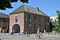
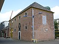
Nederlands: Gevangenis van het Landdrostambt Zutphen. Better known as 't Gevang.
English: Jail of the Landdrostambt of Zutphen. Better known as 't Gevang by locals.
|
This is a category about rijksmonument number 13085
|
| Address |
|
Media in category "Gevangenis (Doetinchem)"
The following 18 files are in this category, out of 18 total.
-
 't Gevang JUL17.jpg 6,000 × 4,000; 12.33 MB
-
 County of Zutphen seal Gevang Doetinchem.jpg 4,000 × 6,000; 6.03 MB
-
 Detail gevangenhuys Doetinchem.JPG 2,944 × 2,140; 1.78 MB
-
 Detail gevangenhuys.JPG 1,084 × 1,340; 409 KB
-
 Doetinchem 155.JPG 640 × 480; 292 KB
-
 Exterieur VOORGEVEL - Doetinchem - 20339545 - RCE.jpg 1,181 × 1,200; 328 KB
-
 Gevang A buiten5.jpg 2,362 × 1,565; 3.15 MB
-
 Gevang A buiten6.jpg 4,712 × 3,084; 11.19 MB
-
 Gevang A voor.jpg 4,731 × 3,134; 8.3 MB
-
 Gevang oude ingang met het wapen gelderland.jpg 1,181 × 1,811; 2.39 MB
-
 Going Dutch II (2013).jpg 1,024 × 617; 362 KB
-
 Het Gevang - Doetinchem - Zomer 2019 (voor + links).jpg 1,920 × 1,282; 525 KB
-
 Het Gevang - Doetinchem - Zomer 2019 (voor + rechts).jpg 1,920 × 1,282; 531 KB
-
 Het gevang.JPG 3,072 × 2,304; 1.78 MB
-
 Ingangspartij - Doetinchem - 20058446 - RCE.jpg 958 × 1,200; 364 KB
-
 Overzicht voorgevel en rechter zijgevel - Doetinchem - 20359543 - RCE.jpg 1,200 × 1,057; 318 KB
-
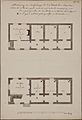 Plattegrond t Gevang Doetinchem.jpg 2,923 × 4,266; 2.02 MB
-
 SAS 5322.jpg 4,928 × 3,264; 7.2 MB


.jpg)
.jpg)
.jpg)


