Category:Geschäftshaus, heute Gemeindeverwaltung (Stadtplatz 46, Aarberg)
Jump to navigation
Jump to search
| Object location | | View all coordinates using: OpenStreetMap |
|---|
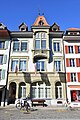
municipal administration building in Aarberg in the canton of Bern, Switzerland  | |||||
| Upload media | |||||
| Instance of | |||||
|---|---|---|---|---|---|
| Part of | |||||
| Location | Aarberg, Seeland administrative district, Seeland administrative region, Bern, Switzerland | ||||
| Street address |
| ||||
| Located on street |
| ||||
| Heritage designation |
| ||||
| Inception |
| ||||
| Elevation above sea level |
| ||||
 | |||||
Media in category "Geschäftshaus, heute Gemeindeverwaltung (Stadtplatz 46, Aarberg)"
The following 3 files are in this category, out of 3 total.
-
 Aarberg-48.jpg 1,200 × 1,800; 395 KB
-
 Aarberg-Gemeindeverwaltung-1903.jpg 1,200 × 1,800; 397 KB
-
 Gemeindeverwaltung in Aarberg BE am Stadtplatz 46 (2018).jpg 3,000 × 4,200; 7.73 MB

.jpg)