Category:Gesäters kyrka
Jump to navigation
Jump to search
| Object location | | View all coordinates using: OpenStreetMap |
|---|
|
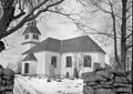
This is a category about an ecclesiastical monument in Sweden, number 21300000002404 in the RAÄ buildings database.
|
church building in Dals-Ed Municipality, Älvsborg County, Sweden  | |||||
| Upload media | |||||
| Instance of | |||||
|---|---|---|---|---|---|
| Location | Dals-Ed Municipality, Västra Götaland County, Sweden | ||||
| Diocese | |||||
| Has use |
| ||||
| Occupant |
| ||||
| Heritage designation |
| ||||
 | |||||
Media in category "Gesäters kyrka"
The following 29 files are in this category, out of 29 total.
-
 Gesäters kyrka - KMB - 16000200011550.jpg 800 × 571; 87 KB
-
 Gesäters kyrka - KMB - 16000200011598.jpg 800 × 555; 100 KB
-
 Gesäters kyrka - KMB - 16000200011609.jpg 800 × 550; 83 KB
-
 Gesäters kyrka - KMB - 16000200011615.jpg 834 × 600; 67 KB
-
 Gesäters kyrka - KMB - 16000200011619.jpg 834 × 600; 63 KB
-
 Gesäters kyrka - KMB - 16000200011622.jpg 842 × 600; 71 KB
-
 Gesäters kyrka - KMB - 16000200011626.jpg 830 × 600; 58 KB
-
 Gesäters kyrka - KMB - 16000200011635.jpg 792 × 600; 63 KB
-
 Gesäters kyrka - KMB - 16000200011636.jpg 431 × 600; 54 KB
-
 Gesäters kyrka - KMB - 16000200011638.jpg 598 × 600; 75 KB
-
 Gesäters kyrka - KMB - 16000200011642.jpg 445 × 600; 53 KB
-
 Gesäters kyrka - KMB - 16000200011646.jpg 433 × 600; 46 KB
-
 Gesäters kyrka - KMB - 16000200011652.jpg 794 × 600; 92 KB
-
 Gesäters kyrka - KMB - 16000200011655.jpg 462 × 600; 47 KB
-
 Gesäters kyrka - KMB - 16000200011658.jpg 435 × 600; 49 KB
-
 Gesäters kyrka - KMB - 16000200011662.jpg 442 × 600; 39 KB
-
 Gesäters kyrka - KMB - 16000200011663.jpg 446 × 600; 42 KB
-
 Gesäters kyrka - KMB - 16000200011665.jpg 427 × 600; 45 KB
-
 Gesäters kyrka - KMB - 16000200011666.jpg 428 × 600; 39 KB
-
 Gesäters kyrka - KMB - 16000200011667.jpg 262 × 600; 28 KB
-
 Gesäters kyrka - KMB - 16000200011674.jpg 421 × 600; 35 KB
-
 Gesäters kyrka - KMB - 16000200011675.jpg 433 × 600; 31 KB
-
 Gesäters kyrka - KMB - 16000200011676.jpg 425 × 600; 35 KB
-
 Gesäters kyrka - KMB - 16000200011677.jpg 431 × 600; 40 KB
-
 Gesäters kyrka - KMB - 16000200011678.jpg 426 × 600; 40 KB
-
 Gesäters kyrka - KMB - 16000200011679.jpg 800 × 578; 84 KB
-
 Gesäters kyrka - KMB - 16000200011680.jpg 266 × 600; 18 KB
-
 Gesäters kyrka old1.jpg 847 × 600; 88 KB
-
 Gäserud, Dalsland, Sweden.jpg 950 × 1,024; 385 KB


