Category:Gerstruber Alpe
Jump to navigation
Jump to search
 | |||||
| Upload media | |||||
| Instance of | |||||
|---|---|---|---|---|---|
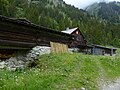
| Location | Oberstdorf, Oberallgäu, Swabia, Bavaria, Germany | ||||
| Street address |
| ||||
| Heritage designation | |||||
 | |||||
This is the category of the Bavarian Baudenkmal (cultural heritage monument) with the ID D-7-80-133-71 (Wikidata)
|
Media in category "Gerstruber Alpe"
The following 8 files are in this category, out of 8 total.
-
 Blick von Gerstrubner Alpe.jpg 3,000 × 4,000; 3.93 MB
-
 Gerstrubenalpe.jpg 640 × 862; 220 KB
-
 Gerstruber Alpe 2020d.jpg 4,000 × 3,000; 4.96 MB
-
 Gerstruber Alpe b.jpg 3,264 × 2,448; 4.51 MB
-
 Gerstrubner Alpe 2020.jpg 4,000 × 3,000; 4.89 MB
-
 Gerstrubner Alpe 2020b.jpg 4,000 × 3,000; 4.94 MB
-
 Gerstrubner Alpe.jpg 4,000 × 3,000; 4.62 MB
-
 Oberstdorf - Gerstruber Alpe v SO 02.JPG 2,272 × 1,704; 1.12 MB


