Category:Gerlachshöhe
Jump to navigation
Jump to search
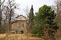
Deutsch: Gerlachshöhe in Werder (Havel), Hoher Weg 69: Ehem. Ausflugslokal mit Aussichtsturm (Ausschank bis in die 1920er Jahre), benannt nach dem Maler Ferdinand August Gerlach, siehe [1].
| Object location | | View all coordinates using: OpenStreetMap |
|---|
 | |||||
| Upload media | |||||
| Instance of | |||||
|---|---|---|---|---|---|
| Location | Werder, Potsdam-Mittelmark District, Brandenburg, Germany | ||||
| Different from | |||||
 | |||||
- ↑ Gerlachshöhe, in Stadtmagazin Wir sind Werder, Ausg. I (2020), S. 14–17
Media in category "Gerlachshöhe"
The following 3 files are in this category, out of 3 total.
-
 Die Gartenlaube (1894) b 697 2.jpg 1,246 × 1,278; 346 KB
-
 Werder-Gerlachshöhe-1.jpg 3,648 × 2,432; 1.41 MB
-
 Werder-Gerlachshöhe-2.jpg 3,205 × 1,803; 1.53 MB
_b_697_2.jpg)
