Category:Gereformeerde Kerk, Zoutkamp
Jump to navigation
Jump to search
| Object location | | View all coordinates using: OpenStreetMap |
|---|
,_S%C3%A2ltkamp.jpg) | |||||
| Upload media | |||||
| Instance of | |||||
|---|---|---|---|---|---|
| Location | Zoutkamp, Het Hogeland, Groningen, Netherlands | ||||
| official website | |||||
 | |||||
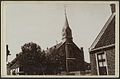
Nederlands: Zoutkamp, Dorpsstraat 37 - Gereformeerde Kerk (1882-1965) - Buiten gebruik 1965 en gesloopt.Vervangen door de huidige kerk.
Media in category "Gereformeerde Kerk, Zoutkamp"
The following 3 files are in this category, out of 3 total.
-
 Interieur - Zoutkamp - 20322818 - RCE.jpg 1,200 × 786; 115 KB
-
 Nije Tsjerke of (earder de grifformearde tsjerke, tsjintwurdich PKN tsjerke), Sâltkamp.jpg 1,600 × 1,068; 1.03 MB
-
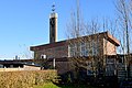
 Zicht vanuit het zuidwesten - Zoutkamp - 20322816 - RCE.jpg 1,200 × 788; 151 KB

