Category:Geomun Island
Jump to navigation
Jump to search
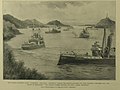
English: Port Hamilton, Geomun-do
한국어: 거문도
中文(繁體):巨文島
group of islands off the south coast of South Korea _Cropped_from_Admiralty_Chart_No_1280_Gyu_To_and_Tonai_Kai,_Published_1915.jpg) | |||||
| Upload media | |||||
| Instance of | |||||
|---|---|---|---|---|---|
| Location |
| ||||
 | |||||
Media in category "Geomun Island"
The following 23 files are in this category, out of 23 total.
-
 Admiralty Chart No 1280 Gyu To and Tonai Kai, Published 1915.jpg 16,244 × 11,108; 39.51 MB
-
 Admiralty Chart No 3366 Fusan Harbour to Port Hamilton, Published 1904.jpg 16,219 × 11,088; 51.78 MB
-
 EB9 Corea.png 2,548 × 3,534; 4.75 MB
-
 Geomundo 1.jpg 3,072 × 2,304; 1.83 MB
-
 Geomundo 10.jpg 3,072 × 2,304; 1.81 MB
-
 Geomundo 11.jpg 3,072 × 2,304; 1.95 MB
-
 Geomundo 12.jpg 3,072 × 2,304; 1.97 MB
-
 Geomundo 2.jpg 3,072 × 2,304; 2.09 MB
-
 Geomundo 3.jpg 3,072 × 2,304; 1.69 MB
-
 Geomundo 4.jpg 3,072 × 2,304; 1.93 MB
-
 Geomundo 5.jpg 2,304 × 3,072; 1.8 MB
-
 Geomundo 6 British Cemetery.jpg 3,072 × 2,304; 2.12 MB
-
 Geomundo 7 British Cemetery.jpg 3,072 × 2,304; 1.8 MB
-
 Geomundo 8 British Cemetery.jpg 2,304 × 3,072; 2.06 MB
-
 Geomundo 9.jpg 3,072 × 2,304; 1.91 MB
-
 Geomundo and Baekdo from Bultanbong.jpg 3,264 × 1,836; 2.92 MB
-
 Geomundo Banner.jpg 3,051 × 436; 339 KB
-
 Geomundo school.jpg 3,072 × 2,304; 1.86 MB
-
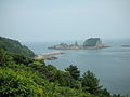
 Korea Geumodo Bireong trail (7800583572).jpg 2,541 × 1,562; 2.84 MB
-
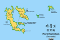 PortHamiltonMap.png 1,138 × 751; 42 KB
-
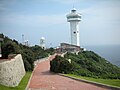
 ROK Territorial Sea Limit Base-point statue at Geomundo Lighthouse.jpg 5,312 × 2,988; 7.66 MB
-
-


.jpg)


