Category:Geology of the Bedford Shale and Berea Sandstone in the Appalachian Basin (1954)
Jump to navigation
Jump to search
Pepper, James F., Wallace De Witt, JR., and David F. Demarest from Pepper, James F., Wallace De Witt, JR., and David F. Demarest; Geology of the Bedford Shale and Berea Sandstone in the Appalachian Basin; Geological Survey Professional Paper 259; United States Department of the Interior, Douglas McKay, Secretary; Geological Survey, W. E. Wrather, Director; United States Government Printing Office, Washington, D.C.; 1954
|
This is a faithful photographic reproduction of a two-dimensional, public domain work of art. The work of art itself is in the public domain for the following reason:
The official position taken by the Wikimedia Foundation is that "faithful reproductions of two-dimensional public domain works of art are public domain".
This photographic reproduction is therefore also considered to be in the public domain in the United States. In other jurisdictions, re-use of this content may be restricted; see Reuse of PD-Art photographs for details. |
Media in category "Geology of the Bedford Shale and Berea Sandstone in the Appalachian Basin (1954)"
The following 52 files are in this category, out of 52 total.
-
 Bulletins of American paleontology (IA bulletinsofameri271274pale).pdf 852 × 1,329, 450 pages; 22.45 MB
-
 Fig 01 Sketch map.jpg 715 × 1,110; 151 KB
-
 Fig 02 Representative sections.jpg 1,344 × 1,625; 191 KB
-
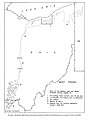 Fig 03 Sketch map.jpg 1,328 × 1,765; 153 KB
-
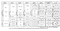 Fig 04 Chart of.jpg 1,803 × 952; 213 KB
-
 Fig 05 Sketch map.jpg 753 × 1,528; 245 KB
-
 Fig 06 Schematic cross section.jpg 1,270 × 308; 56 KB
-
 Fig 07 Sketch map.jpg 1,256 × 1,080; 123 KB
-
 Fig 08 Sketch map.jpg 704 × 1,412; 113 KB
-
 Fig 09 Correlation chart of.jpg 1,403 × 695; 134 KB
-
 Fig 10 Sketch map.jpg 1,331 × 984; 98 KB
-
 Fig 11 Sketch map.jpg 1,070 × 1,717; 158 KB
-
 FIg 12 Correlation of.jpg 1,236 × 935; 238 KB
-
 Fig 13 Sketch map.jpg 751 × 1,103; 156 KB
-
 Fig 14 North wall of the Buckeye quarry, South Amherst.jpg 1,339 × 875; 146 KB
-
 Fig 15 North wall of the Buckeye quarry.jpg 1,365 × 926; 173 KB
-
 Fig 16 Nicholl quarry at Kipton, Camden Township, Lorain County.jpg 1,355 × 909; 177 KB
-
 Fig 17 Pebbles of iron-stained siltstone.jpg 1,343 × 872; 140 KB
-
 Fig 18 Hermit's cave.jpg 1,352 × 836; 163 KB
-
 Fig 19 Outcrop of the black Sunbury shale.jpg 1,344 × 972; 207 KB
-
 Fig 20 Sketch showing three phases.jpg 1,410 × 648; 84 KB
-
 Fig 21 Section so the Berea sandstone in northeastern Ohio.jpg 1,394 × 1,033; 185 KB
-
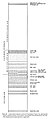 Fig 22 generalized columnar section of Washington County, PA.jpg 794 × 1,744; 129 KB
-
 Fig 23 Generalized cross section showing the relation of the siltstones.jpg 1,819 × 436; 90 KB
-
 Fig 24 Correlations between ne Ohio and nw Pennsylvania.jpg 1,812 × 827; 145 KB
-
 Fig 25 Sketch map showing the relation of the sandstones.jpg 728 × 798; 155 KB
-
 Fig 26 Map showing the area of the Hungry Run sandstone.jpg 1,165 × 1,530; 213 KB
-
 Fig 27 Diagram showing the areal extent of the Red Bedford Delta.jpg 706 × 1,110; 84 KB
-
 Fig 28 Diagram showing the similarity of stream channels.jpg 1,265 × 1,666; 198 KB
-
 Fig 29 Lower Mississippi delta and profile.jpg 738 × 731; 64 KB
-
 Fig 30 Cross sections of three partly aggraded stream valleys.jpg 1,228 × 825; 112 KB
-
 Fig 31 Sketch map showing the relations of the red sediments.jpg 699 × 1,067; 73 KB
-
 Fig 32 Map of the Second Berea bar.jpg 1,278 × 1,827; 343 KB
-
 Fig 33 Map of area in southwestern Trumbull County.jpg 1,278 × 1,729; 228 KB
-
 Fig 34 Approximate area of Cussewago.jpg 1,281 × 1,797; 245 KB
-
 Fig 35 Map showing the different areas of silt or sand deposition.jpg 1,030 × 1,810; 199 KB
-
 Fig 36 Bedford shale and Berea sandstone.jpg 1,344 × 895; 174 KB
-
 Fig 37 East end of the scour channel shown in figure 36.jpg 1,339 × 914; 220 KB
-
 Fig 38 Close-up of the contact of the channel sandstone.jpg 1,352 × 883; 218 KB
-
 Fig 39 Map of a part of Lorain County.jpg 692 × 1,779; 99 KB
-
 Fig 40 Current ripple marks.jpg 1,335 × 908; 177 KB
-
 Fig 41 Current ripple marks in a block of Berea sandstone.jpg 700 × 846; 84 KB
-
 Fig 42 Cross section of the current ripple marks.jpg 716 × 810; 79 KB
-
 Fig 43 Map and cross section of the Buckeye quarry.jpg 1,423 × 1,751; 356 KB
-
 Fig 44 Schematic diagram.jpg 1,306 × 1,783; 232 KB
-
 Fig 45 Diagram showing the three major trends.jpg 692 × 962; 85 KB
-
 Fig 46 Diagram comparing the Second Berea bar and the Gay-Fink Channel.jpg 1,440 × 1,323; 132 KB
-

-
 Fig 48 Sketch map showing the areas of ripple marks.jpg 1,230 × 1,427; 198 KB
-
 Fig 48 Two sections across the sand body at Cabin Creek.jpg 1,462 × 1,686; 180 KB
-
 Fig 50 Oscillation ripple marks.jpg 1,326 × 756; 125 KB
-
 Fig 51 Oscillation ripple marks.jpg 1,334 × 763; 117 KB


