Category:Geology of Thuringia
Jump to navigation
Jump to search
Federal states of Germany:
Subcategories
This category has the following 72 subcategories, out of 72 total.
!
*
+
A
B
- Bohlenwand bei Saalfeld (7 F)
- Bromacker (21 F)
D
E
- Elgersburg-Formation (1 F)
- Erlebnisbergwerk Merkers (77 F)
F
G
- Geology of Thuringian Forest (4 F)
- Gerberstein (18 F)
- Glacial erratics in Thuringia (13 F)
- Glöckner (Berg) (16 F)
- Griffelschiefer-Formation (3 F)
H
I
K
L
- Langensalzaer Travertin (3 F)
M
- Manebach-Formation (1 F)
O
P
- Phycodenschiefer (9 F)
R
S
- Steinbruch Ruhla (4 F)
- Steinerne Rose (5 F)
T
V
W
- Weathering in Thuringia (1 F)
Media in category "Geology of Thuringia"
The following 65 files are in this category, out of 65 total.
-
 Devonian shale with nodular limestone layers.jpg 1,334 × 828; 824 KB
-
 DSC02486 Felsen am Ölknitzer Grund.jpg 3,672 × 4,896; 6.98 MB
-
 DSC02489 Felsen am Ölknitzer Grund,.jpg 4,896 × 3,672; 7.51 MB
-
 DSC02491 Felsen am Ölknitzer Grund.jpg 4,896 × 3,672; 6.67 MB
-
 DSC02492 Felsen am Ölknitzer Grund,,.jpg 4,896 × 3,672; 6.87 MB
-
 DSC02495 Felsen am Ölknitzer Grund..,,.jpg 4,896 × 3,672; 6.17 MB
-
 Ehemaliger Schiefertagebau am Brand.JPG 2,304 × 1,728; 3.06 MB
-
 Elstertal bei Berga 05.jpg 2,508 × 3,660; 6.02 MB
-
 Elstertal bei Berga 06.jpg 2,520 × 4,480; 6.55 MB
-
 Elstertal bei Berga 07.jpg 4,480 × 2,520; 6.76 MB
-
 Elstertal bei Berga 13.jpg 2,292 × 3,762; 8.2 MB
-
 Elstertal bei Berga April 2019 14.jpg 4,160 × 2,392; 7.52 MB
-
 Elstertal bei Berga April 2019 15.jpg 2,520 × 4,026; 7.4 MB
-
 Elstertal bei Berga April 2019 16.jpg 2,502 × 3,912; 7.79 MB
-
 Elstertal-Berga2.JPG 3,648 × 2,736; 3.42 MB
-
 FFH Elstertal Berga 07.jpg 3,000 × 4,000; 4.06 MB
-
 FFH Elstertal Berga 09.jpg 3,000 × 4,000; 3.99 MB
-
 FFH Elstertal Berga Clodramühle 02.jpg 3,000 × 4,000; 3.96 MB
-
 FFH Elstertal Berga Steinberg 1.jpg 3,000 × 4,000; 4.76 MB
-
 FFH Elstertal Berga Steinberg 2.jpg 4,000 × 3,000; 5.01 MB
-
 FFH Elstertal Berga Weg zum Unterhammer 02.jpg 4,000 × 3,000; 3.25 MB
-
 FFH Elstertal Berga Weg zum Unterhammer 03.jpg 3,000 × 4,000; 4.08 MB
-
 FFH Elstertal Berga Weg zum Unterhammer 04.jpg 3,000 × 4,000; 3.69 MB
-
 FFH Elstertal Berga Weg zum Unterhammer 05.jpg 3,000 × 4,000; 3.91 MB
-
 FFH Elstertal Berga Weg zum Unterhammer 06.jpg 4,000 × 3,000; 3.82 MB
-
 FFH Elstertal Berga Weg zum Unterhammer 07.jpg 3,000 × 4,000; 4.1 MB
-
 FFH Elstertal Berga Weg zum Unterhammer 08.jpg 4,000 × 3,000; 3.26 MB
-
 FFH Elstertal Berga Weg zum Unterhammer 09.jpg 4,000 × 3,000; 3.5 MB
-
 FFH Elstertal Berga Weg zum Unterhammer 10.jpg 3,000 × 4,000; 3.34 MB
-
 FFH Elstertal Berga Weg zum Unterhammer 11.jpg 3,000 × 4,000; 3.21 MB
-

-
 FFH Gebiet 5233-304 Muschelkalk-Landschaft westlich Rudolstadt Gölitzwände DE-TH 15.jpg 3,456 × 4,319; 17.05 MB
-
 FFH Gebiet 5233-304 Muschelkalk-Landschaft westlich Rudolstadt Gölitzwände DE-TH 7.jpg 4,608 × 2,593; 4.02 MB
-
 FFH Gebiet 5233-304 Muschelkalk-Landschaft westlich Rudolstadt Gölitzwände DE-TH 8.jpg 4,608 × 2,593; 3.59 MB
-
 FFH Gebiet 5233-304 Muschelkalk-Landschaft westlich Rudolstadt Gölitzwände DE-TH 9.jpg 5,711 × 3,215; 3.76 MB
-
 FFH Gebiet 5233-304 Muschelkalk-Landschaft westlich Rudolstadt Kesselwände DE-TH 2.jpg 4,232 × 2,381; 3.72 MB
-
-
 Geologischer Querschnitt (N-S) von Sollstedt.png 1,819 × 769; 24 KB
-
 Geomap Rhoen.jpg 3,549 × 3,692; 2.69 MB
-
 Gera Milbitz, Schiefergasse.JPG 3,088 × 2,320; 1.65 MB
-
 Hüttchenberg.JPG 3,648 × 2,736; 1.29 MB
-
 Jenalöbnitz 1994-02-05 04.jpg 2,832 × 4,416; 2.87 MB
-
 Kamsdorf section.jpg 1,537 × 1,418; 814 KB
-
 Kupferschiefer Fossilien.JPG 1,634 × 2,062; 681 KB
-
 Lower Permian fanglomerate.jpg 1,829 × 1,223; 1.46 MB
-
 Lower Permian fern leaves.jpg 1,376 × 1,011; 647 KB
-
 LSG Obere Saale Steilhang an der K 181 1 DE-TH.jpg 2,904 × 3,637; 4.61 MB
-
 LSG Obere Saale Steilhang an der K 181 2 DE-TH.jpg 2,864 × 3,579; 4.57 MB
-
 LSG Obere Saale Steilhang an der K 181 3 DE-TH.jpg 3,964 × 2,972; 4.76 MB
-
 Löswand.jpg 4,032 × 3,024; 5.77 MB
-
 Massifseis.jpg 734 × 459; 122 KB
-
 Muschelkalk.jpg 2,448 × 3,264; 3.56 MB
-
 Nationales Geotop Bohlen 1.JPG 1,280 × 960; 786 KB
-
 Nationales Geotop Bohlenwand 2.JPG 960 × 1,280; 477 KB
-
 Nationales Geotop Bohlenwand 3.JPG 1,280 × 960; 452 KB
-
 Nationales Geotop Bohlenwand 4.JPG 960 × 1,280; 459 KB
-
 Opencast mine Kamsdorf.jpg 1,580 × 846; 602 KB
-
 Schieferbruch auf dem Fellberg.JPG 4,928 × 3,264; 5.96 MB
-
 Schieferbruch Fellberg 2.JPG 4,928 × 3,264; 7.78 MB
-
 Siluria (Page 321) BHL47012589.jpg 2,445 × 4,123; 1.43 MB
-
 TambiaClose.jpg 1,662 × 1,272; 2.62 MB
-
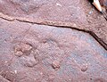
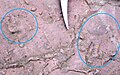 Tetrapodenspuren.jpg 1,722 × 1,071; 2.34 MB
-
 Thüringischer Geologischer Verein, Arnstadt.JPG 3,072 × 2,304; 3.14 MB
-
 Travertin Detail Bad Langensalza.JPG 1,200 × 1,600; 345 KB
-
 WAK Ruhla 037.jpg 2,304 × 1,536; 2.15 MB


_von_Sollstedt.png)


_BHL47012589.jpg)


