Category:Geology of Clark County, Indiana
Jump to navigation
Jump to search
Subcategories
This category has the following 2 subcategories, out of 2 total.
F
Media in category "Geology of Clark County, Indiana"
The following 20 files are in this category, out of 20 total.
-
 Golden Brassfield? - 14911419805.jpg 6,016 × 4,000; 13.03 MB
-
 Golden Brassfield?.jpg 6,016 × 4,000; 14.02 MB
-
 Laurel Formation - 14724848517.jpg 6,016 × 4,000; 11.16 MB
-
 Laurel Formation - 14888242886.jpg 6,016 × 4,000; 11.43 MB
-
 Laurel Formation - 14908296671.jpg 6,016 × 4,000; 12.41 MB
-
 Laurel Formation - 14910933992.jpg 6,016 × 4,000; 12.52 MB
-
 Laurel Formation - 14911038622.jpg 6,016 × 4,000; 11.94 MB
-
 Laurel Formation - 14911383945.jpg 6,016 × 4,000; 11.28 MB
-
 Laurel Formation along Rt 62 - 14724637380.jpg 6,016 × 4,000; 13 MB
-
 Laurel Formation along Rt 62 - 14724673369.jpg 6,016 × 4,000; 13.28 MB
-
 Laurel Formation along Rt 62 - 14908236741.jpg 6,016 × 4,000; 12.92 MB
-
 Laurel Formation along Rt 62 - 14910910582.jpg 6,016 × 4,000; 13.29 MB
-
 Laurel Formation along Rt 62 - 14910980272.jpg 6,016 × 4,000; 13.7 MB
-
 Laurel Formation along Rt 62 - 14911350215.jpg 6,016 × 4,000; 13.41 MB
-
 Laurel Formation along Rt 62 - 14911372645.jpg 6,016 × 4,000; 12.93 MB
-
 Laurel Formation along Rt 62.jpg 6,016 × 4,000; 13.4 MB
-
 Laurel Formation.jpg 6,016 × 4,000; 11.35 MB
-
 Mitchell P. Howes Lime Quarry.jpg 2,816 × 2,112; 1.89 MB
-
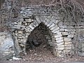 Samuel Starkweather Lime Kiln.jpg 2,816 × 2,112; 1.77 MB
-
 Upper Osgood Formation and Lewisburg Formation.jpg 6,016 × 4,000; 13.96 MB


