Category:Geological maps of Cravant (Loiret)
Jump to navigation
Jump to search
Media in category "Geological maps of Cravant (Loiret)"
The following 6 files are in this category, out of 6 total.
-
 45116-Cravant-géologie.svg 1,052 × 744; 2.45 MB
-
 45019-Baccon-géologie.svg 1,052 × 744; 2.25 MB
-
 45020-Le Bardon-géologie.svg 1,052 × 744; 2.59 MB
-
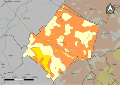
 45116-Cravant-argile.png 3,057 × 2,480; 2.25 MB
-
 45202-Messas-géologie.svg 1,052 × 744; 1.86 MB
-
 45344-Villorceau-géologie.svg 1,052 × 744; 1.73 MB


