Category:Geography of the province of Cuenca
Jump to navigation
Jump to search
Provinces of Spain: Álava · Albacete · Alicante · Almería · Asturias‡ · Ávila · Badajoz · Balearic Islands‡ · Barcelona · Biscay · Burgos · Cáceres · Cádiz · Cantabria‡ · Castellón · Ciudad Real · Córdoba · A Coruña · Cuenca · Gipuzkoa · Girona · Granada · Guadalajara · Huelva · Huesca · Jaén · León · Lleida · Lugo · Madrid‡ · Málaga · Murcia‡ · Navarre‡ · Ourense · Palencia · Las Palmas · Pontevedra · La Rioja‡ · Salamanca · Santa Cruz de Tenerife · Segovia · Seville · Soria · Tarragona · Teruel · Toledo · Valencia · Valladolid · Zamora · Zaragoza · Autonomous cities: Ceuta · Melilla
‡: uniprovincial autonomous communities.
‡: uniprovincial autonomous communities.
Wikimedia category | |||||
| Upload media | |||||
| Instance of | |||||
|---|---|---|---|---|---|
| |||||
Subcategories
This category has the following 17 subcategories, out of 17 total.
C
L
M
- Mancomunidad de La Grajuela (2 F)
- Mancomunidad Informancha (5 F)
- Monte Talayuelo (1 F)
P
- Peña de la Tabarreña (3 F)
R
S
Media in category "Geography of the province of Cuenca"
The following 30 files are in this category, out of 30 total.
-
 007257 - Cuenca (8681791802).jpg 1,800 × 1,200; 2.12 MB
-
 1-AlcaláVega-paisajeUrbano (2017)0280.jpg 4,512 × 3,000; 1.56 MB
-
 1-Algarra-ermitaSanterón (2012)-16.jpg 1,500 × 943; 254 KB
-
 1-Algarra-ermitaSanterón (2012)-17.jpg 1,598 × 976; 239 KB
-
 Afbeelding van Monteagudo.jpg 3,264 × 2,448; 1.37 MB
-
 ArroyoCanadasMarzo2013.JPG 1,600 × 1,200; 316 KB
-
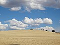 Campo de cereal.JPG 1,600 × 1,200; 481 KB
-
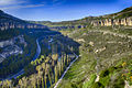
 Canyon near Cuenca, Spain.jpg 3,061 × 1,623; 1.5 MB
-
 Castil de Olivas (Enguídanos -Cuenca).jpg 2,179 × 1,151; 1.95 MB
-
 Confluencia de los rios Gritos y Zahorra desde Valeria.jpg 3,648 × 2,736; 4.91 MB
-
 Cuenca Agosto 2012 653.JPG 3,000 × 4,000; 2.86 MB
-
 Estrechamiento y túneles de las Chorreras - Enguídanos (Cuenca).JPG 2,112 × 2,816; 1,012 KB
-
 ESTRECHO DE PRIEGO1 - panoramio.jpg 2,592 × 1,944; 2.19 MB
-
 Girasolpiedrallana.JPG 1,600 × 1,200; 826 KB
-
 Gorge of Jucar river in autumn - Cuenca - Spain - panoramio.jpg 3,648 × 2,736; 4.69 MB
-
 HUERTA Y CABEZAS MAYO 2010.JPG 2,048 × 1,536; 1.63 MB
-
 La Cañada de mira.JPG 2,048 × 1,536; 978 KB
-
 LA OBRADA Y LAS CABEZA JUNIO DE 2011.JPG 3,872 × 2,592; 4.47 MB
-
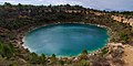 Lagunas de Cañada del Hoyo, pan16 20101108 (5167346167).jpg 5,936 × 2,985; 12.36 MB
-
 OBRADA mayo 2008.JPG 2,592 × 1,944; 2.99 MB
-
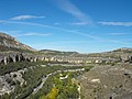
 Paisaje horadado por el río Gritos con el paso del tiempo.jpg 2,736 × 3,648; 4.91 MB
-
 PEÑA SANCHO NOVIEMBRE 2006.JPG 2,048 × 1,536; 2.64 MB
-
 Rio Jucar Cuenca.JPG 2,048 × 1,536; 677 KB
-
 Río Huécar a su paso por Cuenca 09 dic 11.JPG 3,072 × 2,304; 1.85 MB
-
 SAN MIGUEL DE LA VICTORIA 3 - panoramio.jpg 2,592 × 1,944; 2.24 MB
-
 SAN MIGUEL DE LA VICTORIA1 - panoramio.jpg 2,592 × 1,944; 2.27 MB
-
 Terminoalbarañeznorte.jpg 1,600 × 1,200; 841 KB
-
 TORTEJON OCTUBRE 2007.JPG 2,592 × 1,944; 2.61 MB
-
 Valeria villa.JPG 4,592 × 3,056; 7.5 MB
-
 Vistatotal3.jpg 350 × 277; 29 KB
.jpg)
0280.jpg)
-16.jpg)
-17.jpg)


.jpg)


.JPG)


.jpg)


