Category:Geography of Tamano, Okayama
Jump to navigation
Jump to search
Wikimedia category | |||||
| Upload media | |||||
| Instance of | |||||
|---|---|---|---|---|---|
| Category combines topics | |||||
| Tamano | |||||
city in Okayama Prefecture, Japan     | |||||
| Instance of | |||||
| Location | Okayama Prefecture, Japan | ||||
| Legal form |
| ||||
| Inception |
| ||||
| Population |
| ||||
| Area |
| ||||
| Replaces |
| ||||
| official website | |||||
 | |||||
| geography | |||||
science that studies the terrestrial surface, the societies that inhabit it and the territories, landscapes, places or regions that form it when interacting with each other     | |||||
| Pronunciation audio | |||||
| Instance of |
| ||||
| Different from | |||||
| Partially coincident with | |||||
| |||||
Subcategories
This category has the following 8 subcategories, out of 8 total.
Media in category "Geography of Tamano, Okayama"
The following 14 files are in this category, out of 14 total.
-
 From the sky , 児島湾上空から - panoramio - z tanuki.jpg 3,648 × 2,736; 3.43 MB
-
 Kinkouzan.jpg 901 × 655; 727 KB
-
 Japan- Okayama Setouchi tambo art 2016 2.jpg 3,992 × 2,992; 13.42 MB
-
 Japan- Okayama Tamano tambo art 2016 1.jpg 3,992 × 2,992; 13.44 MB
-
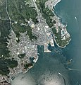 Tamano city center area Aerial photograph.2007.jpg 6,317 × 6,567; 13.38 MB
-
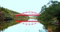 伊達橋 - panoramio.jpg 2,822 × 1,536; 1.25 MB
-
 児島湖 - panoramio.jpg 2,051 × 900; 204 KB
-
 日の出海岸 ❀ 春山に 登りて喜兵衛の 島を追ふ (小原善郎) - panoramio.jpg 3,648 × 1,923; 2.76 MB
-
 渋川港 by takeokahp - panoramio.jpg 4,000 × 3,000; 5.03 MB
-
 玉野市 田井みなと公園 - panoramio (1).jpg 2,497 × 1,551; 1,017 KB
-
 玉野市 田井みなと公園 - panoramio.jpg 2,483 × 1,394; 961 KB
-
 玉野市 石鎚山 (155.6m) ❀ 頂上や 炎天の岩 鎮まれり (小原善郎) - panoramio.jpg 1,024 × 768; 503 KB
-
 玉野市渋川 - panoramio.jpg 2,592 × 1,944; 1.34 MB
-
 玉野市番田. ❀ 海からの 風山からの 風薫る 「鷹羽 狩行」 - panoramio.jpg 3,533 × 2,189; 2.39 MB


.jpg)


