Category:Geography of Sunndal
Jump to navigation
Jump to search
Wikimedia category | |||||
| Upload media | |||||
| Instance of | |||||
|---|---|---|---|---|---|
| |||||
Subcategories
This category has the following 12 subcategories, out of 12 total.
D
- Driva (16 F)
G
- Grøvu (5 F)
I
- Innerdalen (7 F)
- Innerdalstårnet (6 F)
L
- Litldalen (Sunndal) (6 F)
- Løykja-Skorga (1 F)
S
- Skarvdalselva (1 F)
- Storskrymten (5 F)
V
- Vinnufossen (3 F)
Å
- Ålvundelva, Sunndal (1 F)
Ø
Media in category "Geography of Sunndal"
The following 47 files are in this category, out of 47 total.
-
 Cows grazing in Røymoen at the start of Grøvudalen.jpg 4,896 × 3,264; 9.3 MB
-
 Driva, camping Vollan - panoramio (1).jpg 3,456 × 2,304; 2.59 MB
-
 Driva, camping Vollan - panoramio.jpg 2,304 × 3,456; 3.36 MB
-
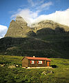
 Gammelsetra tourist cabin in Linndalen.jpg 4,896 × 3,264; 9.04 MB
-
 Gikling.JPG 898 × 588; 108 KB
-
 Giklingdalshytta 1991.jpg 499 × 600; 109 KB
-
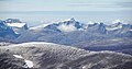
 Grønliskarstinden.JPG 1,600 × 1,200; 679 KB
-
 Grøvu river i Grøvudalen i Sunndalsfjella.jpg 4,896 × 3,264; 8.87 MB
-
 Hydropower site at Holbuvatnet, Sunndal, 2013 June.jpg 3,000 × 2,000; 6.06 MB
-
 Jordalsgrenda-fra-sjøen.jpg 1,601 × 838; 234 KB
-
 Litlskarhøa in Sunndalsfjella.jpg 4,896 × 3,264; 9.53 MB
-
 Litlvatnet - Storvatnet.jpg 1,024 × 768; 89 KB
-
 Morgenlys over Storskrumten.jpg 4,752 × 3,168; 6.04 MB
-
 N591207099 336700 838.jpg 604 × 453; 60 KB
-
 Old mountain farms in Grøvudalen.jpg 4,896 × 3,264; 10.4 MB
-
 Seterfjellet seen from Svøubotnin.jpg 4,896 × 3,264; 12.01 MB
-

-
 Sunndal Ottdalen Ottdalskammen 1569m Nonshöa 1532m Tohatten 1444m IMG 9091.JPG 2,218 × 1,417; 664 KB
-

-
 Sunndal Serkjenebba 1551m Stoplan 1547m Vinnufjellet 1818m IMG 9084.JPG 2,592 × 1,103; 585 KB
-
-

-
 Sunndal Trolla 1800m Skarfjellet 1790m IMG 9086.JPG 1,919 × 1,089; 496 KB
-
 Sunndal Trolla 1800m Skarfjellet 1790m Taaga IMG 9085.JPG 2,381 × 1,162; 660 KB
-
 Sunndal.png 160 × 107; 40 KB
-
 Sunndalsfjella A flatfjellet höglegen.JPG 3,844 × 1,591; 3.59 MB
-
 Sunndalsfjord - Norway - panoramio.jpg 2,213 × 978; 264 KB
-
 Utsyn ut Skirådalen.JPG 2,848 × 2,136; 1.42 MB
-
 View from Merraskaret towards Merraskartjønna.jpg 4,896 × 3,264; 8.67 MB
-
 View from Sagbakkan towards Fjellgardan mountain farms.jpg 4,896 × 3,264; 9.73 MB
-
 View from Svarthaugen towards Reppdalen.jpg 3,847 × 2,325; 5.18 MB
-
 View from Svarthaugen towards Sunndalen.jpg 4,896 × 3,264; 10.68 MB
-
 View from the bridge over Rappa river.jpg 4,896 × 3,264; 11.45 MB
-
 View from Veggasætra over Storvatnet lake in Lindalen.jpg 4,896 × 3,264; 10.25 MB
-
 View north near the dam of Osvatnet, Sunndal, 2013 June.jpg 3,000 × 2,000; 5.63 MB
-
 View of Blekbuvatnet and Romsdalsfjella in the distance from Bollåthøa.jpg 4,896 × 3,264; 9.34 MB
-
 View of Geitådalen from Bollåthøa.jpg 4,896 × 3,264; 8.97 MB
-
 View of Grødalen from Svøulia.jpg 4,896 × 3,264; 8.71 MB
-
 View of Seterfjellet from Storglupåa.jpg 4,896 × 3,264; 8.75 MB
-
 View of Storskarhøa mountain from Bollåthøa.jpg 4,896 × 3,264; 9.54 MB
-
 View of Storvatnet from Styggløypet with Grødalen in the distance.jpg 4,896 × 3,264; 8.67 MB
-
 View of Svarthamaren from Flya up to Merraskaret.jpg 3,597 × 2,416; 4.5 MB
-
 View over Gørashaugen in Sunndalen.jpg 4,896 × 3,264; 10.28 MB
-
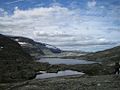
 View over Linndalsvatna lake in Linndalen.jpg 4,896 × 3,264; 9.63 MB
-
 View towards Langranden from Bollåthøa.jpg 4,896 × 3,264; 10.29 MB
-
 Ålvundfjord.jpg 650 × 103; 49 KB
-
 Øksendal.jpg 1,024 × 682; 155 KB

.jpg)


