Category:Geography of Kamo
Jump to navigation
Jump to search
日本語: 新潟県加茂市の地理。
Media in category "Geography of Kamo"
The following 16 files are in this category, out of 16 total.
-
 Central Kamo.JPG 3,524 × 2,642; 1.03 MB
-
 Corydalis orthoceras 070407a.JPG 2,313 × 1,542; 4.08 MB
-
 Kamo city center area Aerial photograph.1975.jpg 6,019 × 4,636; 21.94 MB
-
 Kamo city.PNG 405 × 326; 8 KB
-
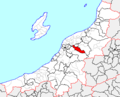
 Kamo in Niigata Prefecture Ja.svg 509 × 515; 10 KB
-
 Kamo in Niigata Prefecture.png 1,381 × 901; 46 KB
-
 Kanbara-komaoka1.JPG 3,872 × 2,592; 4.46 MB
-
 Kuromizu, Kamo, Niigata Prefecture 959-1336, Japan - panoramio (1).jpg 4,608 × 3,456; 5.39 MB
-
 Kuromizu, Kamo, Niigata Prefecture 959-1336, Japan - panoramio.jpg 4,608 × 3,456; 5.85 MB
-
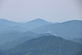 Mt.Hakusan from Mt.Yakemineyama.jpg 1,920 × 1,280; 650 KB
-
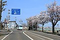 Niigata r9 Kamo Kokucho April2020.jpg 1,568 × 1,044; 459 KB
-
 Niigata r9 Kamo Wakamiyacho April2020.jpg 1,568 × 1,044; 390 KB
-
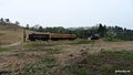 冬鳥越スキーガーデン - panoramio.jpg 2,048 × 1,152; 538 KB
-
 山麓の加茂市から粟ヶ岳.jpg 5,472 × 3,648; 2.85 MB
-
 第一貯水池(加茂市).jpg 5,472 × 3,648; 5.18 MB
-
 第二貯水池(加茂市).jpg 5,472 × 3,648; 3.17 MB


.jpg)


