Category:Geography of Huerfano County, Colorado
Jump to navigation
Jump to search
Counties of Colorado: Adams · Alamosa · Arapahoe · Archuleta · Baca · Bent · Boulder · Chaffee · Cheyenne · Clear Creek · Conejos · Costilla · Crowley · Custer · Delta · Dolores · Douglas · Eagle · El Paso · Elbert · Fremont · Garfield · Gilpin · Grand · Gunnison · Hinsdale · Huerfano · Jackson · Jefferson · Kiowa · Kit Carson · Lake · La Plata · Larimer · Las Animas · Lincoln · Logan · Mesa · Mineral · Moffat · Montezuma · Montrose · Morgan · Otero · Ouray · Park · Phillips · Pitkin · Prowers · Pueblo · Rio Blanco · Rio Grande · Routt · Saguache · San Juan · San Miguel · Sedgwick · Summit · Teller · Washington · Weld · Yuma
City-counties: Denver
City-counties: Denver
Wikimedia category | |||||
| Upload media | |||||
| Instance of | |||||
|---|---|---|---|---|---|
| Category combines topics | |||||
| Huerfano County | |||||
county in Colorado, United States    | |||||
| Instance of | |||||
| Named after | |||||
| Location | Colorado | ||||
| Capital | |||||
| Inception |
| ||||
| Population |
| ||||
| Area |
| ||||
| official website | |||||
 | |||||
| geography | |||||
science that studies the terrestrial surface, the societies that inhabit it and the territories, landscapes, places or regions that form it when interacting with each other     | |||||
| Pronunciation audio | |||||
| Instance of |
| ||||
| Different from | |||||
| Partially coincident with | |||||
| |||||
Subcategories
This category has the following 27 subcategories, out of 27 total.
B
- Badito Cone (5 F)
C
- Cordova Pass (Colorado) (3 F)
- Cucharas Canyon (4 F)
- Cucharas Pass (3 F)
E
- Ellingwood Point (4 F)
G
- Gardner Butte (2 F)
- Goemmer Butte (5 F)
- Greenhorn Mountain (18 F)
H
- Holita Ditch (4 F)
- Huerfano Butte (Colorado) (4 F)
- Huerfano State Wildlife Area (2 F)
L
- Lake Merriam Ditch (2 F)
M
- Mount Mestas (9 F)
- Mosca Pass (3 F)
S
T
- Tres Valles Dike (3 F)
W
- Wahatoya Lake Reservoir (2 F)
- Wahatoya State Wildlife Area (3 F)
- Walsenburg Reservoir (2 F)
Z
- Mount Zwischen (4 F)
Media in category "Geography of Huerfano County, Colorado"
The following 8 files are in this category, out of 8 total.
-
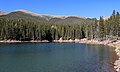 Bear Lake (Huerfano County, Colorado).JPG 5,933 × 3,567; 18.5 MB
-
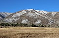
 Carbonate Mountain (Alamosa and Huerfano counties, Colorado).JPG 3,786 × 2,318; 5.41 MB
-
 Iron Mountain (Sangre de Cristo Range).JPG 5,057 × 3,263; 12.77 MB
-
 Little Sheep Mountain.JPG 3,804 × 2,501; 6.26 MB
-
 Rough Mountain (Colorado).JPG 4,401 × 2,778; 6.82 MB
-
 Sheep Mountain Reservoir.JPG 5,835 × 3,772; 16.18 MB
-
 Slide Mountain (Colorado).JPG 3,433 × 2,628; 5.87 MB
-
 Wahatoya Creek.JPG 5,263 × 3,806; 17.88 MB
.JPG)
.JPG)
.JPG)

.JPG)

.JPG)
