Category:Geo-Erlebnispfad Oberjosbach
Jump to navigation
Jump to search
![]() Germany
Germany ![]() Hesse
Hesse ![]() Rheingau-Taunus-Kreis
Rheingau-Taunus-Kreis![]() Niedernhausen
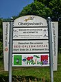
Niedernhausen![]() Oberjosbach- Taunus 373 - 479 m ü.NHN
Oberjosbach- Taunus 373 - 479 m ü.NHN

| Upload media | |||||
| Instance of |
| ||||
|---|---|---|---|---|---|
| Location |
| ||||
| |||||
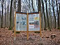
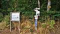
![]() Link zur Tour /
Link zur Tour /
![]() Weg als OSM-Relation /
auf WMT-Karte anzeigen. /
5,2 km Rundwanderweg
Weg als OSM-Relation /
auf WMT-Karte anzeigen. /
5,2 km Rundwanderweg
Media in category "Geo-Erlebnispfad Oberjosbach"
The following 33 files are in this category, out of 33 total.
-
 14-OJB-Frühling.jpg 1,816 × 2,458; 2.66 MB
-
 20-Hohler Stein.jpg 4,032 × 3,024; 7.08 MB
-
 2009-Köhlerei.jpg 2,560 × 1,920; 2.42 MB
-
 Bembel-3,5.jpg 3,024 × 3,024; 6.34 MB
-
 Bembel-Fuchs.jpg 2,986 × 2,986; 6.37 MB
-
 BombenkraterOJB.jpg 2,048 × 3,072; 2.01 MB
-
 Geo-L.jpg 2,012 × 2,066; 1.32 MB
-
 Geo-O.jpg 2,086 × 2,143; 1.42 MB
-
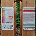
 Geo-Pfad.jpg 3,379 × 1,598; 3.34 MB
-
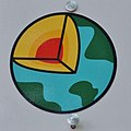 Geo-S.jpg 1,708 × 1,706; 1.01 MB
-
 Geo-Wegweiser-H.jpg 2,882 × 2,882; 3.39 MB
-
 Geopfad-OJB.jpg 4,240 × 2,400; 6.02 MB
-
 Hohler Stein - panoramio (1).jpg 2,272 × 1,504; 1.62 MB
-
 Hohler Stein - panoramio.jpg 1,504 × 2,272; 1.69 MB
-
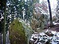 Hohler Stein.jpg 2,560 × 1,920; 1.25 MB
-
 OJB-Geo-1.jpg 2,960 × 2,960; 5.17 MB
-
 OJB-Geo-10.jpg 2,832 × 3,894; 5.83 MB
-
 OJB-Geo-1A.jpg 4,302 × 5,752; 8.31 MB
-
 OJB-Geo-1F.jpg 3,024 × 3,024; 3.33 MB
-
 OJB-Geo-1M.jpg 3,010 × 3,010; 2.92 MB
-
 OJB-Geo-1N.jpg 2,946 × 2,946; 3.4 MB
-
 OJB-Geo-1Z.jpg 3,024 × 4,032; 7.13 MB
-
 OJB-Geo-2B.jpg 4,024 × 3,014; 8.95 MB
-
 OJB-Geo-2K.jpg 2,964 × 2,964; 7.12 MB
-
 OJB-Geo-2V.jpg 2,960 × 3,984; 6.17 MB
-
 OJB-Geo-3.jpg 4,032 × 2,268; 5.08 MB
-
 OJB-Geo-4.jpg 2,996 × 2,996; 4.62 MB
-
 OJB-Geo-5.jpg 2,938 × 3,968; 6.59 MB
-
 OJB-Geo-6.jpg 3,018 × 3,018; 5.34 MB
-
 OJB-Geo-7.jpg 3,018 × 3,018; 6.07 MB
-
 OJB-Geo-8.jpg 2,994 × 2,994; 6.08 MB
-
 OJB-Geo-9.jpg 3,854 × 2,168; 3.33 MB
-
 Rettung-RÜD-242.jpg 4,032 × 3,024; 6.7 MB


.jpg)


