Category:Genossenschaftssiedlung Freidorf
Jump to navigation
Jump to search
| Object location | | View all coordinates using: OpenStreetMap |
|---|
garden city with 150 residential units in 35 buildings in Muttenz in the canton of Basel-Landschaft, Switzerland   | |||||
| Upload media | |||||
| Instance of | |||||
|---|---|---|---|---|---|
| Part of | |||||
| Location | Muttenz, Arlesheim District, Basel-Landschaft, Switzerland | ||||
| Street address |
| ||||
| Architect | |||||
| Heritage designation | |||||
| Inception |
| ||||
| Significant event |
| ||||
 | |||||
Subcategories
This category has the following 2 subcategories, out of 2 total.
G
S
- Johann Friedrich Schär (6 F)
Media in category "Genossenschaftssiedlung Freidorf"
The following 32 files are in this category, out of 32 total.
-
 Bernhard Jaeggi um 1925.jpg 1,547 × 2,048; 1.37 MB
-

-
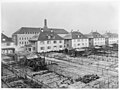
 ETH-BIB-Muttenz, Freidorf, Gartenstadt aus 300 m-Inlandflüge-LBS MH01-004359.tif 6,169 × 4,206; 74.4 MB
-
 ETH-BIB-Muttenz, Freidorf-LBS H1-020279.tif 6,534 × 4,554; 85.2 MB
-
 ETH-BIB-Muttenz, Freidorf-LBS H1-020280.tif 6,475 × 4,518; 83.76 MB
-
 ETH-BIB-Muttenz, Freidorf-Quartier-Inlandflüge-LBS MH03-1130.tif 6,251 × 4,349; 77.89 MB
-
 Freidorf BL 8.3.2.1.60m.jpg 3,619 × 2,640; 4.53 MB
-
 Freidorf BL Aufgang zum Saal 8.3.2.1.14h.jpg 702 × 712; 116 KB
-
 Freidorf BL Bibliothek 8.3.2.1.26m.jpg 3,607 × 2,612; 2.24 MB
-
 Freidorf BL Com 446.jpg 3,505 × 2,539; 9.89 MB
-
 Freidorf BL Gartenseite 8.3.2.1.54m.jpg 3,583 × 2,680; 2.57 MB
-
 Freidorf BL grosser Saal 8.3.2.1.10h.jpg 825 × 606; 171 KB
-
 Freidorf BL Kegelbahn 8.3.2.1.23h.jpg 831 × 602; 124 KB
-
 Freidorf BL Küche 8.3.2.1.25m.jpg 3,607 × 2,612; 2.04 MB
-
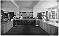 Freidorf BL Laden 8.3.2.1.27m.jpg 3,607 × 2,204; 2.01 MB
-
 Freidorf BL LBS 10159.jpg 4,961 × 3,370; 10.55 MB
-
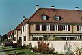
 Freidorf BL mittlere Strasse Vorgärten 8.3.2.1.51m.jpg 3,603 × 2,648; 2.64 MB
-
 Freidorf BL Schulzimmer 8.3.2.1.21h.jpg 830 × 603; 258 KB
-
 Freidorf BL Spielplatz 8.3.2.1.49m.jpg 3,615 × 2,660; 1.91 MB
-
 Freidorf BL Theodor Hoffmann 1924 8.3.2.1.01h.jpg 857 × 584; 158 KB
-
 Freidorf BL Transformatorenstation 8.3.2.1.42m.jpg 3,627 × 2,236; 4.07 MB
-
 Freidorf BL Turnhalle 8.3.2.1.22h.jpg 961 × 520; 154 KB
-
 Freidorf BL Vorraum grosser Saal 8.3.2.1.12h.jpg 828 × 604; 173 KB
-
 Freidorf BL zweiter Laden 8.3.2.1.28m.jpg 3,575 × 2,608; 2.29 MB
-
 Freidorf Genossenschaftshaus 8.3.2.1.03h.jpg 823 × 608; 146 KB
-
 Freidorfgeld.jpg 698 × 453; 116 KB
-
 Hans Schmidt Gartenstadt 1919.jpg 1,277 × 866; 326 KB
-
 Informationstafel Nr. 3. Genossenschaftssiedlung Freidorf in Muttenz.jpg 2,500 × 1,875; 3.46 MB
-
 Informationstafel Nr. 4. Genossenschaftssiedlung Freidorf in Muttenz.jpg 2,500 × 1,875; 3.67 MB
-
 Informationstafel Nr. 8. Genossenschaftssiedlung Freidorf in Muttenz.jpg 2,500 × 1,875; 2.92 MB
-
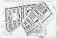
 Lageplan Siedlung Freidorf BL.jpg 994 × 865; 185 KB
-
 Meyer muttenz.jpg 1,465 × 985; 458 KB

,_Gedenktafel._Genossenschaftssiedlung_Freidorf_in_Muttenz.jpg)


