Category:Gemeenteweg 96, Staphorst
Jump to navigation
Jump to search
| Object location | | View all coordinates using: OpenStreetMap |
|---|
 | |||||
| Upload media | |||||
| Instance of | |||||
|---|---|---|---|---|---|
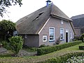
| Location | Staphorst, Overijssel, Netherlands | ||||
| Street address |
| ||||
| Located on street |
| ||||
| Heritage designation |
| ||||
 | |||||
|
This is a category about rijksmonument number 34252
|
| Address |
|
Media in category "Gemeenteweg 96, Staphorst"
The following 5 files are in this category, out of 5 total.
-
 Achtergevel - Staphorst - 20203974 - RCE.jpg 1,190 × 1,200; 356 KB
-
 Staphorst - Gemeenteweg 96 RM34252.JPG 4,608 × 3,456; 2.81 MB
-
 Voor- en linker zijgevel - Staphorst - 20203972 - RCE.jpg 1,188 × 1,200; 381 KB
-
 Voor- en rechter zijgevel - Staphorst - 20203973 - RCE.jpg 1,190 × 1,200; 435 KB
-
 Vooraanzicht - Staphorst - 20203971 - RCE.jpg 1,200 × 812; 319 KB


