Category:Gemeenteweg 251, Staphorst
Jump to navigation
Jump to search
| Object location | | View all coordinates using: OpenStreetMap |
|---|
 | |||||
| Upload media | |||||
| Instance of | |||||
|---|---|---|---|---|---|
| Location | Staphorst, Overijssel, Netherlands | ||||
| Street address |
| ||||
| Located on street |
| ||||
| Heritage designation |
| ||||
 | |||||
|
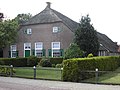
This is a category about rijksmonument number 34224
|
| Address |
|
Media in category "Gemeenteweg 251, Staphorst"
The following 4 files are in this category, out of 4 total.
-
 Achtergevel - Staphorst - 20204181 - RCE.jpg 1,185 × 1,200; 295 KB
-
 Staphorst - Gemeenteweg 251 RM34224.JPG 4,524 × 3,387; 3.71 MB
-
 Voor- en rechter zijgevel - Staphorst - 20204180 - RCE.jpg 1,200 × 1,197; 427 KB
-
 Vooraanzicht - Staphorst - 20204179 - RCE.jpg 1,200 × 810; 267 KB


