Category:Gemeenteweg 243, Staphorst
Jump to navigation
Jump to search
| Object location | | View all coordinates using: OpenStreetMap |
|---|
 | |||||
| Upload media | |||||
| Instance of | |||||
|---|---|---|---|---|---|
| Location | Staphorst, Overijssel, Netherlands | ||||
| Street address |
| ||||
| Located on street |
| ||||
| Heritage designation |
| ||||
 | |||||
|
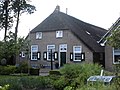
This is a category about rijksmonument number 34223
|
| Address |
|
Media in category "Gemeenteweg 243, Staphorst"
The following 6 files are in this category, out of 6 total.
-
 Aanzicht - Staphorst - 20204173 - RCE.jpg 1,200 × 809; 329 KB
-
 Linker zij- en achtergevel - Staphorst - 20204168 - RCE.jpg 1,200 × 1,197; 393 KB
-
 Staphorst - Gemeenteweg 243 RM34223.JPG 4,521 × 3,381; 3 MB
-
 Voor- en linker zijgevel - Staphorst - 20204167 - RCE.jpg 1,200 × 1,183; 389 KB
-
 Voorgevels - Staphorst - 20204166 - RCE.jpg 1,193 × 1,200; 321 KB
-
 Voorgevels - Staphorst - 20204169 - RCE.jpg 1,191 × 1,200; 417 KB


