Category:Gemeenlandshuis, Monnickendam
Jump to navigation
Jump to search
| Object location | | View all coordinates using: OpenStreetMap |
|---|
Dutch water board meeting hall in Waterland  | |||||
| Upload media | |||||
| Instance of | |||||
|---|---|---|---|---|---|
| Location | Monnickendam, North Holland, Netherlands | ||||
| Street address |
| ||||
| Located on street |
| ||||
| Heritage designation |
| ||||
 | |||||
Nederlands: Gemeenlandshuis van Waterland, Waterlandshuis
|
This is a category about rijksmonument number 30025
|
| Address |
|
Media in category "Gemeenlandshuis, Monnickendam"
The following 13 files are in this category, out of 13 total.
-
 Exterieur - Monnickendam - 20159984 - RCE.jpg 902 × 1,200; 267 KB
-
 Exterieur topgevel - Monnickendam - 20159986 - RCE.jpg 951 × 1,200; 240 KB
-
 Gevel van het Gemeenlandshuis te Monnickendam, RP-T-1982-5-26.jpg 1,324 × 1,652; 227 KB
-

-
 Monnickendam - De Zarken.jpg 4,032 × 3,024; 3.29 MB
-
 Monnickendam - panoramio.jpg 2,020 × 728; 486 KB
-
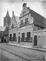
 Monnickendam Gemeenlandshuis van Waterland, Bestanddeelnr 254-3994.jpg 2,634 × 2,629; 924 KB
-

-
 Overzicht voorgevel - Monnickendam - 20159985 - RCE.jpg 894 × 1,200; 236 KB
-
 Traditional Dutch gables at Monnickendam - panoramio.jpg 3,260 × 4,072; 3.13 MB
-
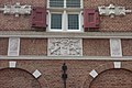 Wapens, Zarken 23, Monnickendam.JPG 3,888 × 2,592; 4.31 MB
-
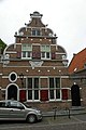
 Waterlandshuis Zarken23 Monnickendam.jpg 3,312 × 1,640; 317 KB
-
 Zarken 23 Monnickendam 29-5-10.jpg 511 × 768; 77 KB


