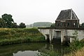
Category:Gemaal H.C. De Jongh (Aalst)
Jump to navigation
Jump to search
| Object location | | View all coordinates using: OpenStreetMap |
|---|
 | |||||
| Upload media | |||||
| Instance of | |||||
|---|---|---|---|---|---|
| Location | Aalst, Brakel | ||||
| Street address |
| ||||
| Located on street |
| ||||
| Heritage designation |
| ||||
 | |||||
|
This is a category about rijksmonument number 523385
|
| Address |
|
Media in category "Gemaal H.C. De Jongh (Aalst)"
The following 2 files are in this category, out of 2 total.
-
 Gemaal H.C. De Jongh.jpg 800 × 534; 223 KB
-
 Overzicht gevel aan de waterzijde - Aalst - 20359414 - RCE.jpg 1,190 × 1,200; 240 KB
