Category:Gefallenendenkmal Brodowin
Jump to navigation
Jump to search
| Object location | | View all coordinates using: OpenStreetMap |
|---|
war memorial in Brandenburg state, Germany  | |||||
| Upload media | |||||
| Instance of | |||||
|---|---|---|---|---|---|
| Commemorates | |||||
| Location | Brodowin, Chorin, Barnim District, Brandenburg, Germany | ||||
| Street address |
| ||||
 | |||||
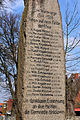
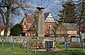
English: Pictures of the war memorial in Brodowin, Chorin municipality, Barnim district, Brandenburg state, Germany.
Deutsch: Ansichten des Gefallenendenkmals in Brodowin, Gemeinde Chorin, Landkreis Barnim, Land Brandenburg, Deutschland.
Français : Photos du monument aux morts de guerre à Brodowin, commune de Chorin, arrondissement de Barnim, état fédéral de Brandebourg, Allemagne
Español: Vistas del monumento a los caidos de las Guerras Mundiales en Brodowin, municipio de Chorin, distrito de Barnim, estado federado de Brandeburgo, Alemania
Address: Brodowiner Dorfstraße 10, Brodowin, 16230 Chorin
Media in category "Gefallenendenkmal Brodowin"
The following 9 files are in this category, out of 9 total.
-
 12-04-06-brodowin-by-RalfR-29.jpg 2,848 × 4,288; 6.18 MB
-
 12-04-06-brodowin-by-RalfR-30.jpg 2,848 × 4,288; 7.15 MB
-
 12-04-06-brodowin-by-RalfR-31.jpg 4,288 × 2,848; 5.72 MB
-
 12-04-06-brodowin-by-RalfR-32.jpg 4,288 × 2,848; 7.08 MB
-
 2010-11-07-brodowin-by-RalfR-04.jpg 2,000 × 3,008; 4.08 MB
-
 Gefallenendenkmal Brodowin 2023 S.jpg 2,947 × 3,885; 4.83 MB
-
 Kriegerdenkmal Brodowin 03.jpg 6,000 × 4,000; 10.22 MB
-
 Kriegerdenkmal Brodowin.jpg 4,251 × 2,754; 9.47 MB
-
 Namenstafel der Gefallenen in Brodowin.jpg 4,267 × 2,832; 9.75 MB


