Category:Gedenkort jüdische Schule (Lingen)
Jump to navigation
Jump to search
| Object location | | View all coordinates using: OpenStreetMap |
|---|
Deutsch: Gedenkort jüdische Schule mit Synagogenplatz.
Media in category "Gedenkort jüdische Schule (Lingen)"
The following 9 files are in this category, out of 9 total.
-
 Gedenkort jüdische Schule Lingen P4060735.jpg 5,472 × 3,648; 15.92 MB
-
 Jüdische Schule Lingen P4060737.jpg 3,648 × 5,472; 14.94 MB
-
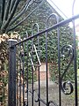 Lingen Gedenkort jüdische Schule Eingangstor.jpg 3,456 × 4,608; 6.55 MB
-
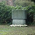 Lingen Gedenkort jüdische Schule Gedenkstein.jpg 3,000 × 3,000; 3.83 MB
-
 Lingen Gedenkort jüdische Schule Infotafel.jpg 3,200 × 3,200; 4.59 MB
-
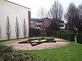 Lingen Gedenkort jüdische Schule Synagogenplatz mit Schule.jpg 4,608 × 3,456; 6.38 MB
-
 Lingen Gedenkort jüdische Schule Synagogenplatz P4060733.jpg 5,472 × 3,648; 19.06 MB
-
 Lingen Gedenkort jüdische Schule Synagogenplatz.jpg 4,608 × 3,456; 6.46 MB
-
 Lingen Gedenkort jüdische Schule.jpg 4,608 × 3,456; 6.67 MB


