Category:Gaydon
Jump to navigation
Jump to search
village in United Kingdom  | |||||
| Upload media | |||||
| Instance of | |||||
|---|---|---|---|---|---|
| Location | Stratford-on-Avon, Warwickshire, West Midlands, England | ||||
| Population |
| ||||
| Area |
| ||||
| Said to be the same as | Gaydon (Wikimedia duplicated page, civil parish) | ||||
| official website | |||||
 | |||||
Български: Гейдън (на английски Gaydon) е село и енория в графство Уорикшър, Англия. Към 2001 г. има население от 376 души.
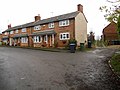
English: Gaydon is a parish and village in Warwickshire, England, close to Leamington Spa. In the 2001 census, the parish had a population of 376.
Français : Gaydon est une paroisse et un village du Warwickshire, en Angleterre, et situé près de Leamington Spa. Lors du recensement mené au Royaume-Uni en 2001, la paroisse comptait 376 habitants.
Subcategories
This category has the following 6 subcategories, out of 6 total.
A
B
- BFI Master Film Store, Gaydon (1 P, 2 F)
S
- St Giles' Church, Gaydon (14 F)
T
- The Malt Shovel, Gaydon (7 F)
Media in category "Gaydon"
The following 124 files are in this category, out of 124 total.
-
-
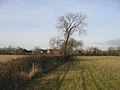
 Autumn Oak by the bridleway - geograph.org.uk - 2147511.jpg 2,000 × 1,507; 312 KB
-
 Banbury Road, Gaydon - geograph.org.uk - 6062950.jpg 1,872 × 1,204; 946 KB
-
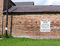
 Barn for sale - geograph.org.uk - 1501239.jpg 640 × 428; 69 KB
-
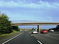
 Bridleway bridge over M40 - geograph.org.uk - 2148198.jpg 2,000 × 1,499; 194 KB
-
 Bridleway bridge over M40 - geograph.org.uk - 2148204.jpg 2,000 × 1,491; 218 KB
-
 Bridleway to Harbury - geograph.org.uk - 2148460.jpg 2,000 × 1,499; 327 KB
-
 Centenary Way bridge, M40 motorway - geograph.org.uk - 3025630.jpg 640 × 480; 59 KB
-
 Converted barns, Gaydon - geograph.org.uk - 1501259.jpg 640 × 428; 51 KB
-
 Development site at Gaydon - geograph.org.uk - 2494368.jpg 640 × 486; 114 KB
-
 Dray at the console.....jpg 2,048 × 1,536; 777 KB
-
 Driveway to Ireland Farm - geograph.org.uk - 3249210.jpg 2,000 × 1,500; 532 KB
-
 Entrance drive to Castle Farm - geograph.org.uk - 2081274.jpg 2,000 × 1,500; 198 KB
-
-
 Exciting Building - geograph.org.uk - 2494365.jpg 640 × 435; 61 KB
-
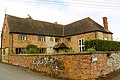 Farmhouse, Gaydon - geograph.org.uk - 1501252.jpg 640 × 428; 82 KB
-
 Farmland and Itchington Holt - geograph.org.uk - 4508830.jpg 640 × 331; 48 KB
-
 Feeder in a field - geograph.org.uk - 5193977.jpg 640 × 480; 159 KB
-
 Field by the M40 - geograph.org.uk - 4508828.jpg 640 × 426; 38 KB
-
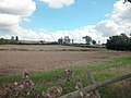
 Fields Near Gaydon - geograph.org.uk - 2172842.jpg 640 × 480; 75 KB
-
 Footbridge over the M40 - geograph.org.uk - 2651741.jpg 640 × 436; 37 KB
-
 Footpath to Ireland Farm - geograph.org.uk - 118525.jpg 640 × 480; 63 KB
-
 Footpath to Ireland Farm - geograph.org.uk - 3249267.jpg 2,000 × 1,500; 584 KB
-
 Footpath towards B4100 - geograph.org.uk - 3249240.jpg 2,000 × 1,500; 516 KB
-
 Gaydon Airfield - geograph.org.uk - 5835524.jpg 2,722 × 2,044; 3.15 MB
-
 Gaydon Fields - geograph.org.uk - 4508832.jpg 640 × 426; 44 KB
-
 Gaydon Fields bridge, M40 motorway - geograph.org.uk - 3025622.jpg 640 × 480; 63 KB
-
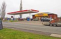
 Gaydon Filling Station - geograph.org.uk - 2741538.jpg 640 × 480; 60 KB
-
 Gaydon Service Station - geograph.org.uk - 4645264.jpg 640 × 483; 416 KB
-
 Gaydon Site Visitor Reception Building - geograph.org.uk - 4651038.jpg 640 × 480; 367 KB
-
 Gaydon Village Hall, Church Road - geograph.org.uk - 4645336.jpg 640 × 482; 517 KB
-
 Gaydon, bus shelter - geograph.org.uk - 3335892.jpg 1,024 × 768; 238 KB
-
 Gaydon, Church Road - geograph.org.uk - 4645321.jpg 640 × 481; 437 KB
-
 Gaydon, roundabout - geograph.org.uk - 3335888.jpg 1,024 × 768; 147 KB
-
 Gaydon-Church Lane - geograph.org.uk - 2738638.jpg 640 × 480; 71 KB
-
 Gaydon-Pimple Lane - geograph.org.uk - 2744300.jpg 640 × 431; 54 KB
-
 Gaydon.jpg 640 × 480; 62 KB
-
 JAGUAR C-X16 DESIGN (6213603610).jpg 1,191 × 383; 313 KB
-
 Junction 12 bridge, M40 motorway - geograph.org.uk - 3025627.jpg 640 × 480; 56 KB
-
 Junction 12 overbridge, M40 - geograph.org.uk - 2686228.jpg 640 × 430; 41 KB
-
 Lake at Gaydon Heritage Motor Centre - geograph.org.uk - 4651043.jpg 640 × 481; 471 KB
-
 Lay-by on B4100 - geograph.org.uk - 3250315.jpg 2,000 × 1,500; 595 KB
-
 M40 - approaching Junction 12 - geograph.org.uk - 3249083.jpg 640 × 430; 34 KB
-
 M40 - bridge at Gaydon Fields - geograph.org.uk - 3250793.jpg 640 × 430; 32 KB
-
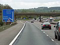
 M40 - Junction 12 - geograph.org.uk - 3249086.jpg 640 × 400; 35 KB
-
 M40 bridge near Thorn Hill - geograph.org.uk - 2686252.jpg 640 × 430; 41 KB
-

-
 M40 Gaydon Road crosses by bridge - geograph.org.uk - 3104656.jpg 3,648 × 2,736; 1.34 MB
-
 M40 junction 12 slip roads - geograph.org.uk - 2081263.jpg 2,000 × 1,500; 183 KB
-
 M40 motorway near Gaydon Hill Farm - geograph.org.uk - 3025620.jpg 640 × 480; 45 KB
-
-
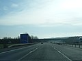
 M40 northbound - geograph.org.uk - 3224354.jpg 640 × 480; 39 KB
-
 M40 northbound - geograph.org.uk - 3224356.jpg 640 × 480; 53 KB
-
 M40 northbound - geograph.org.uk - 3224357.jpg 640 × 480; 44 KB
-
 M40 northbound - geograph.org.uk - 3224358.jpg 640 × 480; 43 KB
-
 M40 northbound - geograph.org.uk - 3224359.jpg 640 × 480; 48 KB
-
 M40 overbridge at Gaydon Fields - geograph.org.uk - 3155115.jpg 640 × 385; 41 KB
-
 M40 southbound nears junction 12 - geograph.org.uk - 2829648.jpg 640 × 482; 32 KB
-

-
 M40, Overbridge near Thorn Hill - geograph.org.uk - 2463888.jpg 640 × 430; 28 KB
-

-
 Mixed Crop - geograph.org.uk - 2494352.jpg 640 × 510; 165 KB
-
 Northbound M40 at Junction 12 - geograph.org.uk - 3299451.jpg 640 × 480; 361 KB
-
 Northbound M40, Gaydon Fields - geograph.org.uk - 3299436.jpg 640 × 480; 391 KB
-
 Northbound M40, Junction 12 - geograph.org.uk - 3299444.jpg 640 × 480; 367 KB
-
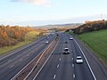
 Northbound M40, north of Gaydon - geograph.org.uk - 3299460.jpg 640 × 480; 344 KB
-
 Old Baling Machine - geograph.org.uk - 2147613.jpg 2,000 × 1,502; 235 KB
-
 Old Toll House by the B4451, Gaydon - geograph.org.uk - 6114719.jpg 640 × 393; 82 KB
-
 Passageway by St Giles Church, Gaydon - geograph.org.uk - 2647236.jpg 2,000 × 1,501; 402 KB
-
 Perimeter fence, DMC Kineton - geograph.org.uk - 475438.jpg 480 × 640; 116 KB
-
 Period house - geograph.org.uk - 1501275.jpg 640 × 428; 76 KB
-
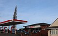 Petrol station in Gaydon - geograph.org.uk - 6062968.jpg 1,848 × 1,162; 1,013 KB
-
 Pond in front of the collections centre - geograph.org.uk - 5691506.jpg 1,600 × 1,200; 439 KB
-
 RMD Kineton - geograph.org.uk - 410466.jpg 640 × 479; 40 KB
-
 Road closed - geograph.org.uk - 5097118.jpg 2,000 × 1,333; 1.44 MB
-
-
 Rover 3500S - geograph.org.uk - 4277798.jpg 3,648 × 2,736; 4.61 MB
-
 Slip road, J12, M40 - geograph.org.uk - 4508824.jpg 640 × 426; 44 KB
-
 Southbound M40 at Junction 12 - geograph.org.uk - 3299320.jpg 640 × 480; 340 KB
-
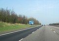
 Southbound M40, Junction 12 (for Gaydon) - geograph.org.uk - 3526785.jpg 640 × 480; 248 KB
-

-
 Start of bridleway to Harbury - geograph.org.uk - 2148189.jpg 2,000 × 1,510; 237 KB
-
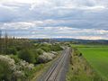
 Stored railway stock - geograph.org.uk - 141779.jpg 640 × 480; 49 KB
-
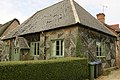
 Thatched house, Gaydon - geograph.org.uk - 1501397.jpg 640 × 428; 74 KB
-

-
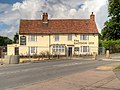
 The Gaydon Inn (1), Banbury Road, Gaydon - geograph.org.uk - 3366999.jpg 1,024 × 653; 138 KB
-
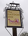 The Gaydon Inn (2) - sign, Banbury Road, Gaydon - geograph.org.uk - 3367013.jpg 785 × 1,024; 133 KB
-
 The Gaydon Inn - geograph.org.uk - 2738632.jpg 640 × 480; 63 KB
-
 The Gaydon Inn - geograph.org.uk - 4645301.jpg 640 × 480; 455 KB
-
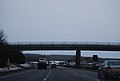
 The M40 runs under a footbridge - geograph.org.uk - 5763601.jpg 2,700 × 2,002; 328 KB
-
 The M40 runs under Long Lane - geograph.org.uk - 5763599.jpg 2,700 × 2,025; 347 KB
-
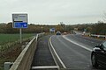
 The M40 slip road at Gaydon - geograph.org.uk - 6235626.jpg 3,466 × 1,871; 1.41 MB
-
 Vater Removals - geograph.org.uk - 4116086.jpg 640 × 480; 71 KB
-
 View from bridleway bridge over M40 - geograph.org.uk - 2166473.jpg 2,000 × 1,502; 208 KB
-
 View from bridleway bridge over M40 - geograph.org.uk - 2166489.jpg 2,000 × 1,496; 204 KB
-
 Village hall in Gaydon - geograph.org.uk - 1501246.jpg 640 × 428; 92 KB
-
 Village Hall, Gaydon - geograph.org.uk - 729809.jpg 640 × 480; 95 KB
-
 Warning signs for junc 12 M40 north - geograph.org.uk - 2866454.jpg 640 × 448; 61 KB
-
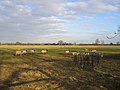 Winter sheep - geograph.org.uk - 94509.jpg 640 × 480; 84 KB
-
 Blossom - geograph.org.uk - 158533.jpg 640 × 480; 327 KB
-
 Burton Hill - geograph.org.uk - 110141.jpg 640 × 480; 42 KB
-
 Dassett hills - geograph.org.uk - 3991.jpg 640 × 480; 47 KB
-
 Derelict Barn - geograph.org.uk - 110127.jpg 640 × 480; 47 KB
-
 DSDA Kineton - geograph.org.uk - 475453.jpg 640 × 480; 122 KB
-
 End of the road - geograph.org.uk - 98202.jpg 640 × 480; 111 KB
-
 Footbridge at Ireland farm - geograph.org.uk - 118526.jpg 640 × 480; 106 KB
-
 Gaydon - geograph.org.uk - 141804.jpg 640 × 480; 336 KB
-
 Gaydon - geograph.org.uk - 3987.jpg 640 × 480; 66 KB
-
 Gaydon Layby - geograph.org.uk - 56903.jpg 640 × 480; 145 KB
-
 Ireland Farm - geograph.org.uk - 110122.jpg 640 × 480; 46 KB
-
 Keep Out^ - geograph.org.uk - 110131.jpg 640 × 480; 51 KB
-
 Landfill site - geograph.org.uk - 94475.jpg 640 × 480; 96 KB
-
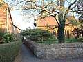
 Lane by Gaydon Church - geograph.org.uk - 141808.jpg 640 × 480; 338 KB
-
 Lighthorne Heath - geograph.org.uk - 94729.jpg 640 × 480; 106 KB
-
 South Gaydon - geograph.org.uk - 56904.jpg 640 × 480; 148 KB
-
 Temple Herdewyke - geograph.org.uk - 3989.jpg 640 × 480; 54 KB
-
 View east from the Burton Hills - geograph.org.uk - 162924.jpg 640 × 480; 288 KB
-
 View NE from the Burton Hills - geograph.org.uk - 162899.jpg 640 × 480; 270 KB
-
 View north from the Burton Hills - geograph.org.uk - 162878.jpg 639 × 478; 204 KB
-
 View SW from the Burton Hills - geograph.org.uk - 162862.jpg 640 × 480; 237 KB
-
 View towards Burton Hill Farm - geograph.org.uk - 141786.jpg 640 × 480; 46 KB
-
 View towards the Dassett Hills - geograph.org.uk - 141783.jpg 640 × 480; 46 KB
-
 Warwickshire Centenary Way - geograph.org.uk - 93682.jpg 640 × 480; 233 KB
-
 Windmill Hill, Burton Dasset Country Park - geograph.org.uk - 162830.jpg 640 × 480; 251 KB


_-_geograph.org.uk_-_3025624.jpg)


_-_geograph.org.uk_-_3526785.jpg)


,_Banbury_Road,_Gaydon_-_geograph.org.uk_-_3366999.jpg)
_-_sign,_Banbury_Road,_Gaydon_-_geograph.org.uk_-_3367013.jpg)


.jpg)