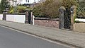
Category:Gatepiers and wall of Beach Lawn, Waterloo
Jump to navigation
Jump to search
| Object location | | View all coordinates using: OpenStreetMap |
|---|
grade II listed wall and gate piers, Waterloo, Sefton, Merseyside, England, UK  | |||||
| Upload media | |||||
| Instance of | |||||
|---|---|---|---|---|---|
| Location | Sefton, Merseyside, North West England, England | ||||
| Heritage designation |
| ||||
 | |||||
Media in category "Gatepiers and wall of Beach Lawn, Waterloo"
The following 2 files are in this category, out of 2 total.
-
 Gatepiers and wall of Beach Lawn, Waterloo 1.jpg 5,116 × 2,897; 19.31 MB
-
 Gatepiers and wall of Beach Lawn, Waterloo 2.jpg 5,126 × 2,403; 17.44 MB
