Category:Gasthof Traube (Roggwil)
Jump to navigation
Jump to search
| Object location | | View all coordinates using: OpenStreetMap |
|---|
|
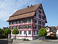
This is a category about a cultural property of regional significance in Switzerland with KGS number 10225
|
 | |||||
| Upload media | |||||
| Instance of | |||||
|---|---|---|---|---|---|
| Part of | |||||
| Location |
| ||||
| Street address |
| ||||
| Heritage designation |
| ||||
 | |||||
Media in category "Gasthof Traube (Roggwil)"
The following 2 files are in this category, out of 2 total.
-
 ETH-BIB-Roggwil aus 400 m-Inlandflüge-LBS MH01-003486.tif 6,185 × 4,607; 81.67 MB
-
 Traube Roggwil TG.jpg 4,000 × 3,000; 4.87 MB