Category:Gare de Villiers-Saint-Georges
Jump to navigation
Jump to search
| Object location | | View all coordinates using: OpenStreetMap |
|---|
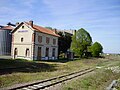
railway station in Villiers-Saint-Georges, France  | |||||
| Upload media | |||||
| Instance of | |||||
|---|---|---|---|---|---|
| Location | Villiers-Saint-Georges, Seine-et-Marne, Île-de-France, Metropolitan France, France | ||||
| Owned by | |||||
| Date of official opening |
| ||||
| Date of official closure |
| ||||
| Elevation above sea level |
| ||||
| Connecting line | |||||
 | |||||
Media in category "Gare de Villiers-Saint-Georges"
The following 5 files are in this category, out of 5 total.
-
 Gare de Villiers-Saint-Georges - PN 29.jpg 2,560 × 1,920; 1.27 MB
-
 Gare de Villiers-Saint-Georges 01.jpg 2,560 × 1,920; 1.25 MB
-
 Gare de Villiers-Saint-Georges 02.jpg 2,560 × 1,920; 1.26 MB
-
 Gare-Villiers-Saint-Georges-CPancienne.jpg 1,636 × 1,016; 989 KB
-
 Villiers-Saint-Georges - La Gare 5.jpg 935 × 613; 194 KB


