Category:Gare de Riom - Châtel-Guyon
Jump to navigation
Jump to search
| Object location | | View all coordinates using: OpenStreetMap |
|---|
railway station  | |||||
| Upload media | |||||
| Instance of | |||||
|---|---|---|---|---|---|
| Location | Riom, Puy-de-Dôme, Auvergne-Rhône-Alpes, Metropolitan France, France | ||||
| Transport network | |||||
| Owned by | |||||
| Operator | |||||
| Date of official opening |
| ||||
| Elevation above sea level |
| ||||
| Connecting line | |||||
| Adjacent station | |||||
 | |||||
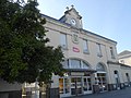
Français : La gare de Riom - Châtel-Guyon est une gare ferroviaire de la ligne de Saint-Germain-des-Fossés à Nîmes-Courbessac, située sur le territoire de la commune de Riom, près de Châtel-Guyon, dans le département de Puy-de-Dôme en région [:fr:Auvergne
Occitan : La gara de Riom (Puèi-Domat), en Auvèrnha.
Media in category "Gare de Riom - Châtel-Guyon"
The following 12 files are in this category, out of 12 total.
-
 Gare de Riom - Châtel-Guyon, passage souterrain.jpg 1,960 × 4,032; 6.56 MB
-
 Gare de Riom-Châtel-Guyon.jpg 4,608 × 3,456; 3.42 MB
-
 Gare de Riom.jpg 3,072 × 2,304; 2.39 MB
-
 Locomotive britannique, gare de Riom.jpg 4,032 × 2,268; 7.67 MB
-
 Parking vélos sécurisé Riom 2016-08-13.JPG 2,816 × 2,112; 1.59 MB
-
 Parvis et façade gare Riom 2016-08-13.JPG 2,816 × 1,584; 1.37 MB
-
 Riom-FR-63-gare-a1.jpg 4,032 × 3,024; 4.38 MB
-
 Riom-FR-63-gare-a2.jpg 4,032 × 3,024; 4.08 MB
-
 Riom-FR-63-gare-a3.jpg 3,521 × 2,114; 3.85 MB
-
 Riom-FR-63-gare-a4.jpg 4,737 × 2,845; 6.59 MB
-
 Riom-FR-63-gare-a5.jpg 3,024 × 4,032; 4.78 MB
-
 Riom-FR-63-gare-a6.jpg 4,032 × 3,024; 4.48 MB


