Category:Gare de Rethel
Jump to navigation
Jump to search
| Object location | | View all coordinates using: OpenStreetMap |
|---|
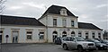
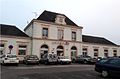
railway station in Rethel, France  | |||||
| Upload media | |||||
| Instance of | |||||
|---|---|---|---|---|---|
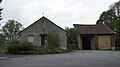
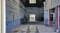
| Location | Rethel, Ardennes, Grand Est, Metropolitan France, France | ||||
| Transport network | |||||
| Owned by | |||||
| Operator | |||||
| Date of official opening |
| ||||
| Elevation above sea level |
| ||||
| Connecting line | |||||
| Adjacent station | |||||
 | |||||
Media in category "Gare de Rethel"
The following 7 files are in this category, out of 7 total.
-
 Gare CBR 7110.JPG 4,592 × 2,576; 3.53 MB
-
 Gare CBR 7112.JPG 3,662 × 2,054; 2.13 MB
-
 Gare CBR 7113.JPG 4,592 × 2,576; 2.54 MB
-
 Gare de Rethel 9208.JPG 4,592 × 2,576; 2.83 MB
-
 Gare de Rethel 9210.jpg 4,592 × 2,212; 567 KB
-
 Gare de Rethel-2015.jpg 1,696 × 1,120; 541 KB
-
 Rethel-FR-08-la gare-01.jpg 2,972 × 2,229; 2.54 MB


