Category:Gare de Montchanin
Jump to navigation
Jump to search
| Object location | | View all coordinates using: OpenStreetMap |
|---|
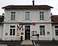
Français : La gare de Montchanin est une gare ferroviaire française des lignes de Nevers à Chagny et du Coteau à Montchanin, située sur la commune de Montchanin dans le département de la Saône-et-Loire et la région Bourgogne.
railway station in Montchanin, France .jpg) | |||||
| Upload media | |||||
| Instance of | |||||
|---|---|---|---|---|---|
| Location | Montchanin, canton of Montchanin | ||||
| Transport network | |||||
| Owned by | |||||
| Operator | |||||
| Date of official opening |
| ||||
| Elevation above sea level |
| ||||
| Connecting line | |||||
| Adjacent station | |||||
 | |||||
Media in category "Gare de Montchanin"
The following 10 files are in this category, out of 10 total.
-
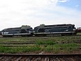
 17.08.92 Montchanin Class X 4300 and BB 66204+BB 66293 (42863955971).jpg 1,370 × 912; 1.65 MB
-
 17.08.92 Montchanin X4716 & X8713 (6385715157).jpg 1,486 × 1,000; 336 KB
-
 BB 67200, Montcha. - 71.jpg 1,136 × 852; 222 KB
-
 Class20-CFD.jpg 673 × 927; 223 KB
-
 Couple X 4500 à Montchanin (2008).jpg 2,020 × 1,516; 1.6 MB
-
 Ferro. Montchanin, 71.jpg 1,136 × 852; 375 KB
-
 Gare de Montchanin 2.jpg 4,096 × 3,072; 4.85 MB
-
 Gare de Montchanin-2014.jpg 1,608 × 1,272; 1,017 KB
-
 Gare de Montchanin.jpg 1,726 × 1,058; 781 KB
-
 X 4500 à Montchanin (2008).jpg 1,821 × 1,354; 1.49 MB
.jpg)


.jpg)


.jpg)