Category:Gare de Lambel - Camors
Jump to navigation
Jump to search
| Object location | | View all coordinates using: OpenStreetMap |
|---|
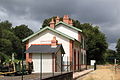
railway station in Camors, France  | |||||
| Upload media | |||||
| Instance of | |||||
|---|---|---|---|---|---|
| Location | Camors, Morbihan, Brittany, Q88521114, Metropolitan France, France | ||||
| Owned by | |||||
| Date of official opening |
| ||||
| Date of official closure |
| ||||
| Elevation above sea level |
| ||||
| Connecting line | |||||
 | |||||
Français : La gare de Lambel - Camors est une gare ferroviaire française (fermée) de la ligne d'Auray à Pontivy, située au village de Lambel sur le territoire de la commune de Camors, dans le département du Morbihan en région Bretagne.
Media in category "Gare de Lambel - Camors"
The following 6 files are in this category, out of 6 total.
-
 Bâtiment voyageurs de la gare de Lambel - Camors par Cramos.JPG 2,500 × 1,667; 1.39 MB
-
 Gare-Lambel-Camors-BV-voie-2010.jpg 3,008 × 2,000; 1.17 MB
-
 Gare-Lambel-Camors-dir-Auray.jpg 3,008 × 2,000; 1.18 MB
-
 Gare-Lambel-Camors-dir-Pontivy-2010.jpg 3,008 × 2,000; 2.3 MB
-
 Gare-Lambel-Camors-Impassedelagare.jpg 3,008 × 2,000; 1.07 MB
-
 Vlrpresse.jpg 88 × 58; 13 KB


