
Category:Gare de La Levade
| Object location | | View all coordinates using: OpenStreetMap |
|---|
railway station in La Grand-Combe, France  | |||||
| Upload media | |||||
| Instance of | |||||
|---|---|---|---|---|---|
| Location | La Grand-Combe, Gard, Occitania, Metropolitan France, France | ||||
| Transport network | |||||
| Owned by | |||||
| Operator | |||||
| Date of official opening |
| ||||
| Elevation above sea level |
| ||||
| Connecting line | |||||
| Adjacent station | |||||
 | |||||
Français : La gare de La Levade est une gare ferroviaire de la ligne de Saint-Germain-des-Fossés à Nîmes-Courbessac (également appelée Ligne des Cévennes), située au village de La Levade sur le territoire de la commune de La Grand-Combe, dans le département du Gard en région Languedoc-Roussillon.
Media in category "Gare de La Levade"
The following 4 files are in this category, out of 4 total.
-
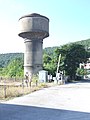 Le Levade Chateau d'Eau 9606.JPG 2,616 × 3,488; 2.13 MB
-
 Le Levade Railway 9603.JPG 3,488 × 2,616; 2.31 MB
-
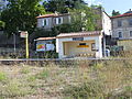 Le Levade Railway Station 9601.JPG 3,488 × 2,616; 2.2 MB
-
 Le Levade railway station 9604.JPG 3,488 × 2,616; 2.17 MB


