Category:Gare de Durtol - Nohanent
Jump to navigation
Jump to search
| Object location | | View all coordinates using: OpenStreetMap |
|---|
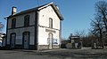
railway station in Durtol, France  | |||||
| Upload media | |||||
| Instance of | |||||
|---|---|---|---|---|---|
| Location | Durtol, Puy-de-Dôme, Auvergne-Rhône-Alpes, Metropolitan France, France | ||||
| Transport network | |||||
| Owned by | |||||
| Operator | |||||
| Elevation above sea level |
| ||||
| Connecting line | |||||
| Adjacent station | |||||
 | |||||
Français : La gare de Durtol-Nohanent est une halte ferroviaire française de la ligne d'Eygurande - Merlines à Clermont-Ferrand, située sur le territoire de la commune de Durtol, à proximité de Nohanent, dans le département du Puy-de-Dôme en région Auvergne.
Media in category "Gare de Durtol - Nohanent"
The following 6 files are in this category, out of 6 total.
-
 Abris gare Durtol 2015-04-10.JPG 2,816 × 2,112; 1.95 MB
-
 BV de la gare de Durtol - Nohanent par Cramos.JPG 3,000 × 2,000; 1.67 MB
-
 Gare de Durtol et poteau indicateur 2015-04-10.JPG 2,816 × 2,112; 1.74 MB
-
 Gare de Durtol-Nohanent.JPG 1,920 × 1,080; 740 KB
-
 Voies gare Durtol vers Clermont-F 2015-04-10.JPG 2,816 × 2,112; 2.32 MB
-
 Vue générale de la gare de Durtol - Nohanent par Cramos.JPG 3,000 × 2,000; 2.21 MB


