Category:Gare de Champigneulles
Jump to navigation
Jump to search
| Object location | | View all coordinates using: OpenStreetMap |
|---|
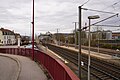
railway station in Champigneulles, France  | |||||
| Upload media | |||||
| Instance of | |||||
|---|---|---|---|---|---|
| Location | Champigneulles, Meurthe-et-Moselle, Grand Est, Metropolitan France, France | ||||
| Transport network | |||||
| Owned by | |||||
| Operator | |||||
| Date of official opening |
| ||||
| Elevation above sea level |
| ||||
| Connecting line | |||||
| Adjacent station | |||||
 | |||||
Français : La gare de Champigneulles est une gare ferroviaire de la ligne de Noisy-le-Sec à Strasbourg-Ville (Paris - Strasbourg), située sur le territoire de la commune de Champigneulles, banlieue nord de Nancy, dans le département de Meurthe-et-Moselle, en région Lorraine. C'est une halte ferroviaire de la Société nationale des chemins de fer français (SNCF) desservie par des trains TER Lorraine.
Media in category "Gare de Champigneulles"
The following 2 files are in this category, out of 2 total.
-
 Gare Champigneulles 1307333.jpg 3,984 × 2,656; 8.5 MB
-
 Gare de Champigneulles.jpg 3,072 × 2,304; 2.46 MB
