Category:Gare d'Urçay
Jump to navigation
Jump to search
| Object location | | View all coordinates using: OpenStreetMap |
|---|
railway station in La Perche, France  | |||||
| Upload media | |||||
| Instance of | |||||
|---|---|---|---|---|---|
| Location | La Perche, canton of Saulzais-le-Potier | ||||
| Transport network | |||||
| Owned by | |||||
| Operator | |||||
| Date of official opening |
| ||||
| Elevation above sea level |
| ||||
| Connecting line | |||||
| Adjacent station | |||||
 | |||||
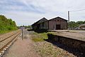
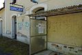
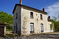
Français : La gare d'Urçay est une gare ferroviaire française de la ligne de Bourges à Miécaze, située sur le territoire de la commune de La Perche, dans le département du Cher, en région Centre-Val de Loire. Néanmoins la gare est également située à proximité immédiate du bourg centre de la commune d'Urçay, dont elle n'est séparée que par le Cher, dans le département de l'Allier en région Auvergne-Rhône-Alpes.
Media in category "Gare d'Urçay"
The following 13 files are in this category, out of 13 total.
-
 GareUrcay2016 01.jpg 6,000 × 4,000; 4.76 MB
-
 GareUrcay2016 02.jpg 6,000 × 4,000; 5.03 MB
-
 GareUrcay2016 04.jpg 6,000 × 4,000; 5.75 MB
-
 GareUrcay2016 07.jpg 6,000 × 4,000; 5.41 MB
-
 GareUrcay2016 11.jpg 6,000 × 4,000; 4.97 MB
-
 GareUrcay2016 16.jpg 6,000 × 4,000; 3.41 MB
-
 GareUrcay2016 22.jpg 6,000 × 4,000; 4.68 MB
-
 GareUrcay2016 29.jpg 6,000 × 4,000; 7.67 MB
-
 GareUrcay2016 37.jpg 6,000 × 4,000; 3.63 MB
-
 GareUrcay2016 46.jpg 6,000 × 4,000; 5.2 MB
-
 GareUrcay2016 56.jpg 6,000 × 4,000; 4.63 MB
-
 GareUrcay2016 67.jpg 6,000 × 4,000; 4.18 MB
-
 GareUrcay2016 79.jpg 6,000 × 4,000; 4.35 MB


