Category:Friedensgedächtniskirche (Lauchhammer)
Jump to navigation
Jump to search
| Object location | | View all coordinates using: OpenStreetMap |
|---|
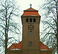
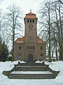
church building in Lauchhammer-Ost, Germany  | |||||
| Upload media | |||||
| Instance of | |||||
|---|---|---|---|---|---|
| Named after | |||||
| Location | Lauchhammer, Oberspreewald-Lausitz District, Brandenburg, Germany | ||||
| Heritage designation | |||||
 | |||||
This is the category of the Brandenburger Baudenkmal (cultural heritage monument) with the ID 09120220 (Wikidata)
|
Media in category "Friedensgedächtniskirche (Lauchhammer)"
The following 7 files are in this category, out of 7 total.
-
 28404-Lauchhammer-1952-Kirche und Neue Schule-Brück & Sohn Kunstverlag.jpg 1,545 × 1,000; 589 KB
-
 28487-Lauchhammer-1952-Ost, Kirche-Brück & Sohn Kunstverlag.jpg 1,000 × 1,545; 638 KB
-
 29257-Lauchhammer-1956-Ost, Kirche, Waldschule-Brück & Sohn Kunstverlag.jpg 1,522 × 1,000; 346 KB
-
 Lauchhammer friedensgedaechtniskirche Ausschnitt.jpg 1,576 × 1,480; 449 KB
-
 Lauchhammer friedensgedaechtniskirche b.jpg 2,448 × 3,264; 1.33 MB
-
 Lauchhammer friedensgedaechtniskirche c.jpg 1,976 × 2,222; 1,019 KB
-
 Lauchhammer friedensgedaechtniskirche.JPG 2,448 × 3,264; 1.71 MB


