Category:Friarton Bridge
Jump to navigation
Jump to search
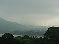
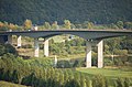
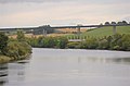
English: The Friarton Bridge is a concrete road bridge that carries the M90 motorway across the River Tay outside Perth, Scotland. The bridge carries four lanes (two in each direction) without hard shoulder. The M90 motorway finishes and the road continues as the A90 just north of the bridge, making this the most northerly motorway bridge in the United Kingdom.
box girder bridge crossing the River Tay, Scotland  | |||||
| Upload media | |||||
| Instance of | |||||
|---|---|---|---|---|---|
| Location | Perth, Perth and Kinross, Scotland | ||||
| Crosses | |||||
| Carries | |||||
| Inception |
| ||||
| Date of official opening |
| ||||
 | |||||
Media in category "Friarton Bridge"
The following 30 files are in this category, out of 30 total.
-
 A Tay-folyó Perth-nél (The Tay River at Perth) - panoramio.jpg 1,600 × 1,200; 409 KB
-
 Approach to Friarton Bridge - geograph.org.uk - 2761980.jpg 1,726 × 970; 164 KB
-
 Constructing Friarton Bridge - geograph.org.uk - 1109320.jpg 640 × 406; 72 KB
-
 Friarton Bridge - geograph.org.uk - 102623.jpg 640 × 480; 144 KB
-
 Friarton Bridge - geograph.org.uk - 2079936.jpg 640 × 480; 110 KB
-
 Friarton Bridge - geograph.org.uk - 3258097.jpg 2,048 × 1,536; 829 KB
-
 Friarton Bridge - geograph.org.uk - 477448.jpg 640 × 434; 247 KB
-
 Friarton Bridge - geograph.org.uk - 563428.jpg 640 × 424; 60 KB
-
 Friarton Bridge - geograph.org.uk - 6968.jpg 640 × 480; 59 KB
-
 Friarton Bridge - geograph.org.uk - 959582.jpg 640 × 480; 81 KB
-
 Friarton Bridge at dusk - geograph.org.uk - 1090355.jpg 640 × 427; 100 KB
-
 Friarton Bridge at Perth - geograph.org.uk - 1033973.jpg 640 × 427; 55 KB
-
 Friarton Bridge beneath.jpg 1,280 × 960; 272 KB
-

-
 Friarton Bridge Perth.jpg 800 × 600; 792 KB
-

-
 Friarton Bridge, Perth - geograph.org.uk - 3518507.jpg 830 × 709; 408 KB
-
 Friarton Bridge, Perth, from the air - geograph.org.uk - 3605952.jpg 1,024 × 681; 217 KB
-
 Friarton Bridge.jpg 640 × 480; 172 KB
-
 Friartontay.jpg 640 × 404; 51 KB
-
 Kinnoull Hill from the Friarton Bridge - geograph.org.uk - 3061683.jpg 3,264 × 2,448; 3.55 MB
-
 M90 Motorway - geograph.org.uk - 563587.jpg 640 × 416; 55 KB
-
 Magdelene Hill - geograph.org.uk - 1506524.jpg 640 × 480; 91 KB
-
 River Tay and Friarton Bridge - geograph.org.uk - 46028.jpg 640 × 480; 125 KB
-

-
 Summit cairn of Moncreiffe Hill - geograph.org.uk - 644072.jpg 640 × 480; 90 KB
-
 The River Tay and Friarton bridge.jpg 640 × 480; 123 KB
-
 The Tay - geograph.org.uk - 565764.jpg 640 × 424; 28 KB
-
 Under Friarton Bridge - geograph.org.uk - 2672422.jpg 1,600 × 1,600; 548 KB
-
 View from Kinnoul Hill.jpg 480 × 640; 75 KB
_-_panoramio.jpg)


