Category:Frey-Haus (Brandenburg)
Jump to navigation
Jump to search
| Object location | | View all coordinates using: OpenStreetMap |
|---|
museum in Brandenburg an der Havel, Brandenburg state, Germany  | |||||
| Upload media | |||||
| Instance of | |||||
|---|---|---|---|---|---|
| Location | Brandenburg an der Havel, Brandenburg, Germany | ||||
| Heritage designation | |||||
 | |||||
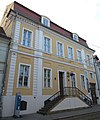
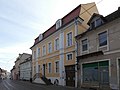
This is the category of the Brandenburger Baudenkmal (cultural heritage monument) with the ID 09145485 (Wikidata)
|
Media in category "Frey-Haus (Brandenburg)"
The following 7 files are in this category, out of 7 total.
-
 Frey-Haus (Brandenburg) 1.jpg 5,184 × 3,888; 10.16 MB
-
 Frey-Haus (Brandenburg) 2.jpg 3,888 × 4,647; 11.34 MB
-
 Frey-Haus (Brandenburg).jpg 5,184 × 3,888; 8.21 MB
-
 Frey-Haus Ausstellung.jpg 4,896 × 3,672; 8.58 MB
-
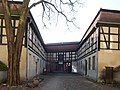 Frey-Haus Hinterhaus.jpg 4,377 × 3,284; 6.6 MB
-
 Frey-Haus in Brandenburg.jpg 5,184 × 3,888; 8.04 MB
-
 Freyhaus Brandenburg.jpg 3,873 × 2,909; 5.59 MB
_1.jpg)
_2.jpg)
.jpg)


