Category:Freiwillige Feuerwehr Groß Schulzendorf
Jump to navigation
Jump to search
| Object location | | View all coordinates using: OpenStreetMap |
|---|
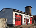
fire station in Brandenburg state, Germany  | |||||
| Upload media | |||||
| Instance of | |||||
|---|---|---|---|---|---|
| Location | Groß Schulzendorf, Ludwigsfelde, Teltow-Fläming District, Brandenburg, Germany | ||||
 | |||||
English: Pictures of the station of the volunteer firefighters in Groß Schulzendorf, Ludwigsfelde municipality, Teltow-Fläming district, Brandenburg state, Germany.
Deutsch: Ansichten des Gerätehauses der Freiwilligen Feuerwehr in Groß Schulzendorf, Stadt Ludwigsfelde , Landkreis Teltow-Fläming , Land Brandenburg , Deutschland.
Français : Photos du depôt des pompiers volontaires à Groß Schulzendorf, ville de Ludwigsfelde, , arrondissement de Teltow-Fläming , état federé de Brandebourg , Allemagne.
Español: Vistas del parque de los bomberos voluntarios en Groß Schulzendorf, ciudad de Ludwigsfelde, distrito de Teltow-Fläming , estado federado de Brandeburgo , Alemania.
Address: Dorfaue 11a, Groß Schulzendorf, 14974 Ludwigsfelde
Media in category "Freiwillige Feuerwehr Groß Schulzendorf"
The following 3 files are in this category, out of 3 total.
-
 Fire Station Gross Schulzendorf.JPG 690 × 530; 54 KB
-
 Freiwillige Feuerwehr Groß Schulzendorf 2024 S.jpg 4,032 × 2,268; 1.81 MB
-
 Ludwigsfelde Groß Schulzendorf Freiwillige Feuerwehr.jpg 4,608 × 3,456; 3.62 MB

