Category:Fredriksten Fortress, maps
Jump to navigation
Jump to search
Media in category "Fredriksten Fortress, maps"
The following 19 files are in this category, out of 19 total.
-

-

-
 Fredrikshald (Halden), Norway, 1718.jpg 6,365 × 5,781; 6.85 MB
-
 Fredrikshald (Halden), Norway, 1765.jpg 4,524 × 3,214; 3.83 MB
-
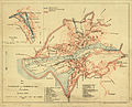 Fredrikshald (Halden), Norway, 1884.jpg 3,280 × 2,657; 1.71 MB
-
 Fredrikshald1660.jpg 3,277 × 2,466; 1.36 MB
-

-
 Plan der Belagerung von Fridrichshall angefangen von Carl dem XII (glorwürd... - CBT 5871356.jpg 5,623 × 4,760; 10.58 MB
-
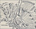 Plan of the Siege of Frederiksten 1718.jpg 1,307 × 1,045; 1.66 MB
-
 Situations Charta von denen Bahuus Lehn und Norwegißcen Gränzen - no-nb krt 00748.jpg 5,091 × 6,628; 11.1 MB
-
 Smålenenes amt nr 100- Grund Riss af Friderichsteens Fæstning med underligende forts, 1800.jpg 10,017 × 6,482; 6.91 MB
-

-

-
 Smålenenes amt nr 12- Kart over Fredrikssten og Fredrikshald, 1710.jpg 7,583 × 5,014; 4.85 MB
-
 Smålenenes amt nr 120- Situantions Kaart over Terrainet om Fæstningen Fredrikssteen, 1824.jpg 10,835 × 7,370; 16.27 MB
-
 Smålenenes amt nr 121- Kart af Fredrikshald med Omegn, 1830.jpg 6,130 × 4,533; 4.89 MB
-
 Smålenenes amt nr 130- Kart over Fredrikssten Fæstning, 1883.jpg 7,839 × 7,904; 14.63 MB
-
 Smålenenes amt nr 15- Die Festung Fridrichstein, 1715.jpg 6,989 × 6,996; 6.54 MB
-
 Smålenenes amt nr 16- Kart over Fredrikssten, 1715.jpg 6,927 × 7,042; 5.2 MB
.jpg)
_p1.663_Schwedischer_Angriff_auf_die_d%C3%A4nische_Festung_Frederikshald_(1716).jpg)
,_Norway,_1718.jpg)
,_Norway,_1765.jpg)
,_Norway,_1884.jpg)

.png)


